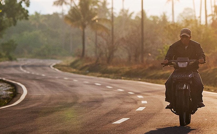
“When it’s red you stop; when it’s green, you go,” explains my driver, Sunil, when I ask him about Nepal’s road rules. He revs the motorbike’s engine and I jolt backwards, clutching his leather jacket, as we pull into a stream of zigzagging tuk-tuks and two-wheel vehicles. Trucks and cars and bikes and buses and motorcycles scream towards us, along with an orchestra of horns and incessant beeping. “We’re not driving an airplane, you know,” he says, stroking the fuel tank like he’s taming a tiger. “This is just a little bike.”
The first five minutes spent playing chicken with traffic in Nepal bursts any romantic bubble or Long Way Round fantasies you may have about crossing the country on the back of a motorbike. Reality check: it’s scary and loud, and the only wind in your hair is the dirty black smoke being emitted from every diesel and two-stroke engine you pass.
For the next 11 days, I’ll be circumnavigating this tiny mountainous nation, taking in a range of hand-picked highlights. With an experienced local guide in the driver’s seat, and a support vehicle carrying most of our stuff, this trip gives intrepid travellers an in-your-face authentic experience of some of the globe’s most famous landmarks.
We slalom along the four-lane highway, dodging the potholes and wandering animals that litter our route out of Kathmandu. Buffalos walk blindly into the road and goats bolt from side alleys. A truck passes closely and we swerve to avoid making a fresh corpse out of a cow.
“You get fined if you hit one of those,” hollers Sunil from somewhere under his helmet, purple cap and Ray-Bans.
As we ride into a winding, narrow laneway, a vehicle ahead of us hits its brakes hard and one of my six companions, John, a guy from Sydney who’s riding solo, veers to the left to miss it, landing sideways in a ditch. Although he’s not hurt, it’s a reminder that this is not your regular out-of-town excursion. The risks of ultimate freedom are real. The excitement can come at a cost.
Back on track, we finally replace big tokes of CO2 with large lungfuls of alpine air. Emerald fields come into view, and little huts the colour of dried biscuits spread out on the hillside. Pewter-grey boulders pepper the side of a rushing river we follow all the way to our first official pit stop.
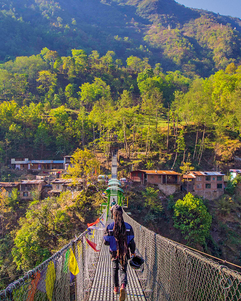
The Last Resort is exactly that – the final place to get your kicks before hitting the Tibet border. Located three hours away from Nepal’s crowded capital, it’s a stunning spot with comfortable safari-style tents set up along the water’s edge, and numerous hair-raising activities. Here you can run river rapids or go canyoning, mountain biking or hiking. Try canyon swinging, do a forest ropes course or, at 160 metres, brave one of the world’s highest bungee jumps.
As if to encourage – or deter – visitors from actually attempting the leap, the only thing connecting the road to the actual town and tents is the bungee bridge itself. Walking slowly towards the platform, my palms like ice and my guts in a mess, I pass pint-sized men and women lugging baskets of rocks, bags of cement and a variety of vegetables.
“How many times have you done this?” I ask the guy who is now shackling my feet. “You crazy?” he laughs. “Never. See how high this is?” I pray the multicoloured Tibetan flags stretched overhead in an arc are just there for decoration. Then I shuffle close to the edge, raise my arms level with my shoulders, dive forward and let the silence swallow me.
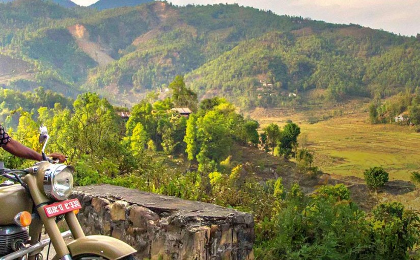
The next morning, the rush in my body has subsided to a gentle buzz, and a heavy downfall of rain has brushed the valleys with a glossy sheen. We wave goodbye to our camp and say hello again to our choice of steed – the Royal Enfield Bullet.
A symbol of British and Indian manufacturing pride, the Enfield is one of the world’s oldest motorcycle brands still in production. The Indian police and army once used them to patrol the country’s borders, considering it the most suitable bike for the job thanks to its super-cushy seat.
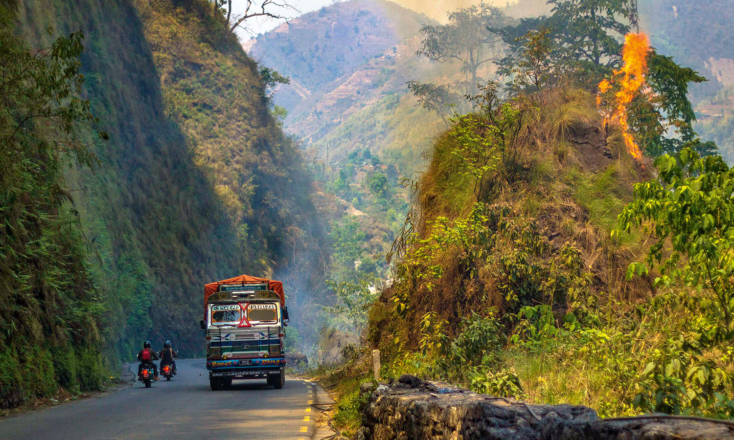
As we bounce along the ‘road’ – a painful 12-kilometre avalanche of rocks and pebbles (the Nepalese version of gravel) heading to the border town of Kodari – tall, leafy trees give way to glorious Himalayan mountains, leathery faces grow rounder and pink cheeks more plump.
On arrival we shuffle through hordes of sherpas and people with packages containing undetected contraband (I’m told beer hidden underneath sleeping babies is popular) to the Sino-Nepal Friendship Bridge, the link between Nepal and Tibet.
On the far side of the thick white line in the middle of the crossing are 20 or so stone-faced Chinese guards in perfectly pressed attire, standing in front of a penitentiary-like compound. On the Nepalese side, there are a couple of guys milling about in shabby uniforms, next to a landslide of rubbish and a truck depot.
A young man suddenly appears, waving a large umbrella at me (odd, seeing as the midday sun is cranking and there’s not a rain cloud in sight). More guys arrive, all wildly yelling, pointing their brollies at my hands and looking very unhappy. It occurs to me that it’s the camera I’m holding that is causing the ruckus. After several failed attempts to quell their excitement, and to avoid getting arrested for being a spy, we leave for Nagarkot, a one-night-stand type of town that counts Mount Everest among its nearest neighbours.
Sometimes Nagarkot boasts spectacular sunrises and glimpses of the world’s tallest peak; other times the clouds close in and you’re left to do the walk of shame back to your hotel. Unfortunately, the latter is the case for us this morning, although the iridescent sky behind the outline of the Himalayan peaks and the sight of tiny villages on the hilltops still make the trip worthwhile.
Over the next two days, we rattle along the often-hazardous roads with the rumble of the four-stroke, 500cc engine as our soundtrack. Sometimes we ride for three hours; sometimes we ride for seven. Sometimes the road is good; sometimes it’s non-existent. Often, the towering pines and burnt-orange spring hues make it easy for me to forget where I am – until a woman walks by heaving half a tree and a hamper of stones strapped to her forehead.
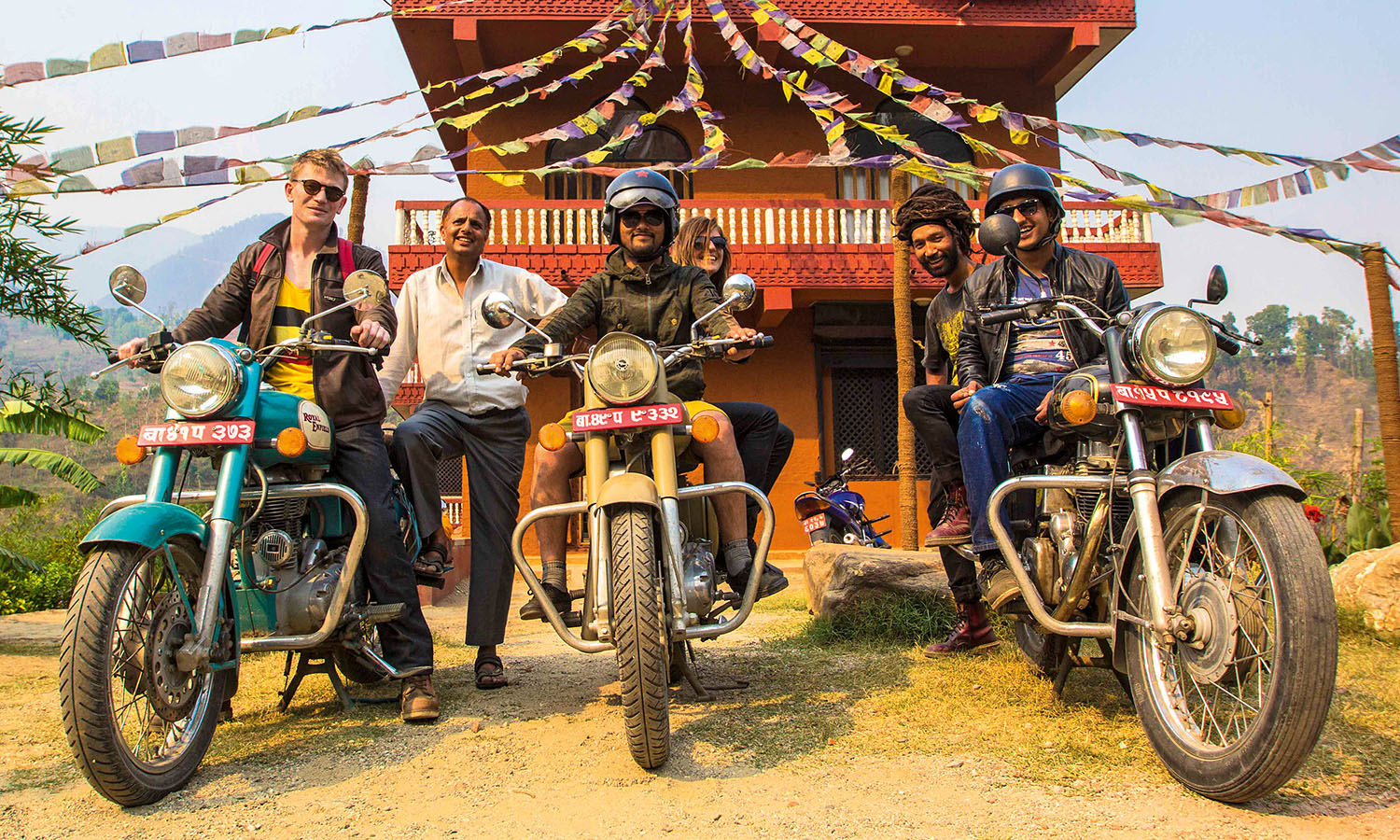
Every hour or so we stop to drink tea, stretch our legs, play carrom board (a table-hockey-like game) with the locals and admire the views. It’s time well spent getting to know my companions better, including Junesh, our tour leader, whose knee-length dreads make him look like a mishmash of Bob Marley and Lord Shiva, and 23-year-old Sunil, the owner of the back I’ve been hugging for the past few days.
Somewhere between wandering the cobbled streets of Bhaktapur with babas on bikes and monks in the latest Nikes, and elephant trekking and dodging horse-drawn carts in Chitwan National Park, I actually begin to believe there’s method to all the madness on the roads. I now don’t blink when we turn into oncoming traffic and I’ve perfected a new seated yoga pose.
On day six, I discover that the best place to be with heat exhaustion is anywhere but on the back of a motorcycle in Nepal. My brain rattles around in my skull, my kidneys jar every time we hit a pothole, I’ve developed a two-pack-a-day habit from all the fumes and I can no longer feel my bum. Sunil affectionately pats my leg every so often, either to check I’m OK or to check I’m still there.
Eventually I retire to the comfort of the support vehicle, where I sleep off my highway hangover much to the dismay of my driver, Arjun. “I am 54,” he says, touching his nose. “Can you believe it? I look 25. Because I drink a jug of tea to clear the head every morning and then 30 minutes jumping up and down. You could not possibly look this good!”
The peaceful, pilgrim-rich town of Lumbini, the birthplace of Buddha, comes at just the right time. After a little temple sightseeing, quiet reflection and rest, I’m ready to hit the highway again.
“My wife, she vomit on this road,” Arjun attempts to reassure me the next morning about the 200-kilometre drive ahead (our longest yet). “More than 100 times. Up and down, and round and round, always twisting, always vomiting.”
Though the road is, indeed, very twisty, the fresh oxygen, pretty valleys dotted with hot-pink rhododendrons, which make me think of Provence in France, and near-vertical 3000-metre slopes are plenty to keep me enthused.
Eight hours later, we ride with black faces, totally beat, into Pokhara where we are met with a queue that’s 20 motorcycles long and four bikes deep at the petrol station – the sign that a fuel strike is on the cards (a recurring crisis here). With locals forbidden to drive the following day, unless they want to risk the police confiscating their keys, we find ourselves a bit stuck.
Fortunately, Pokhara is not a bad place to hang out for couple of days. Situated next to the beautiful Phewa Lake, the town marks the finish line for the Annapurna Circuit trek and is the start of a dozen or so more hikes, rafting trips and paragliding tours.
As Asia’s answer to Queenstown, New Zealand, it is the perfect place to drink a few well-earned Everest beers and take in the spectacular 8000-metre frosty tops of Annapurna, Annapurna II and Machapuchare, or the Fish Tail, from the air. Although, as I find out, when you catch a good spin-worthy wind and mountain view during your paraglide you then land at the Feel Great Restaurant not actually feeling all that great.
With our last days on the Enfield – and in Nepal – drawing to a close, and with the strike having emptied the streets, we ride effortlessly to our final destination: Royal Beach Camp. A ‘kayak clinic’ and rafting retreat with tents and thatched huts set up on a sandy beach next to the sea-green Trisuli River, this place is outdoor living at its very best.
There’s a distinct change of pace here. Days disappear in a haze, with afternoons spent battling icy water in rafts and evenings lost while gorging on momos (steamed dumplings) and sucking back beers in the open-air beach cabana. Bonded by dust, drama and the driving experience of the past two weeks, we recap the highs and the lows.
Over 11 days, we’ve ridden more than 2000 kilometres on dirt roads, potholed roads and no roads. During this time I’ve: seen just two speed zones, one working indicator and zero street signs; suffered everything from bruises and blisters to sunstroke, exhaust poisoning and dehydration; upset a posse of umbrella-waving border guards; thrown myself off a bridge; and been paragliding in the Himalayas.
As someone who also spent his fair share of time doing things tough with a bunch of bikers once said: “Life is not a journey to the grave with the intention of arriving safely in a pretty and well-preserved body, but rather to skid in broadside, thoroughly used up, totally worn out, and loudly proclaiming: ‘Wow – what a ride!’” I’m with you, Hunter S Thompson.
I am pretty much naked inside the third and hottest steam room of a neighbourhood hammam in the ancient walled city of Fez. The attendant is applying rhassoul, a fine mineral-rich clay mask enriched with Morocco’s famous restorative argan oil, to my pink glowing skin, which she has just scrubbed with a zeal most Westerners would reserve for dirty floors. There must be 50 voluptuous local women here with me, some with fussy toddlers, others accompanied by prepubescent girls whose curious eyes can’t help straying towards the scrawny stranger.
I’d wanted to get under the skin of this most sacred and secret of Morocco’s cities – I just didn’t expect the experience to verge on literal. Sure, in Marrakesh’s fancy resort spas there are rarified private hammams, all marble benches and tiptoeing staff catering to precious Western sensibilities. Here, I’m washing – and sweating – in the midst of a convivial and noisy scene the way people have done for centuries, before homes had access to running water. My young guide Aisha (who I met just this morning) is lathering herself beside me before she sloshes a bucket of cold water over both of us. It is hotter than a pistol in here and we move to the outer steam room to start cooling off. In the communal changing rooms, the married women dress in pretty underwear, Western clothes and, finally, kaftans and head scarves, then we all file out into a chilly November evening as the last call to prayer rings out from the local mosque.
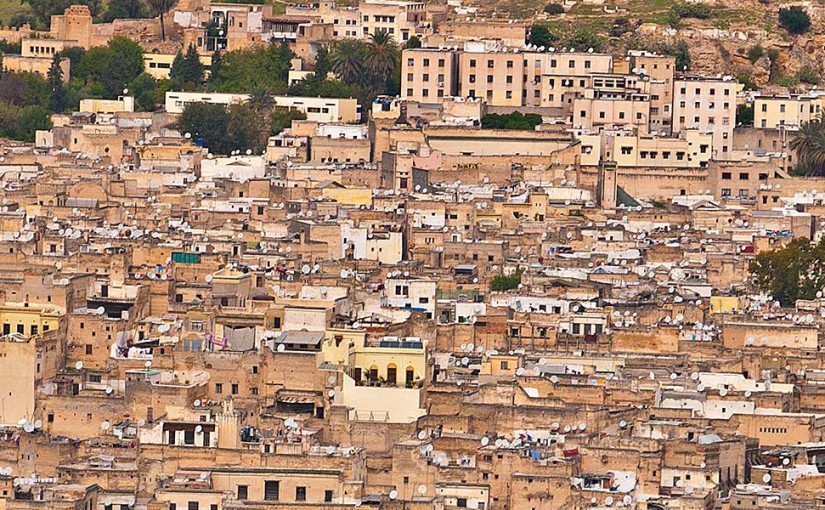
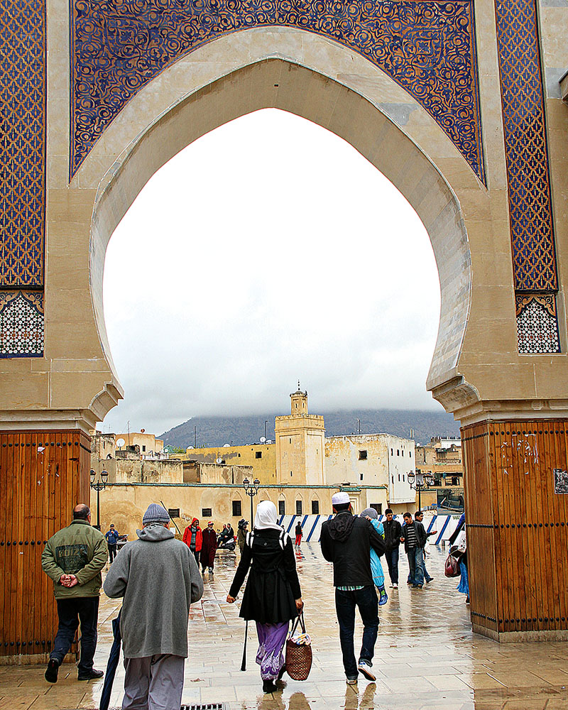
Fez is the cultural and spiritual heart of Morocco, its UNESCO World Heritage-listed medina the world’s largest car-free urban area. American writer and longtime Moroccan resident Paul Bowles called it “an enchanted labyrinth sheltered from time”, and today people live and work in its 9000 laneways much the same way as they have done for a thousand or so years. Donkeys remain the main form of transport. Long lines of mourners still visit the tomb of its founder, Moulay Iddriss II, the great-great-grandson of the prophet Mohammed, while its University of Al-Karaouine, founded in the ninth century, is the world’s oldest institution of higher learning.
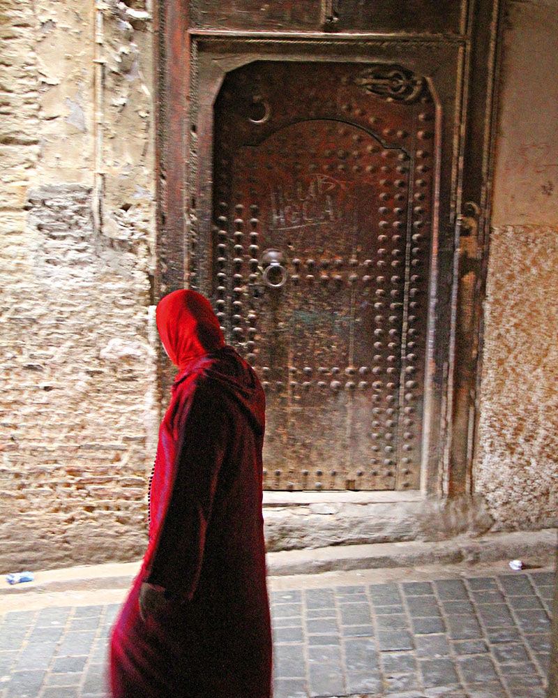
On my first visit to Fez I had felt very much the tourist with an official guide leading me along a hackneyed path of historical highlights and shopping meccas, where I’d bargained for leather, carpet and jewellery in government-approved shops. Yet I was fascinated by this place of secrets, of veiled women and hooded men navigating narrow passageways that weave between high windowless walls. It was so radically different to Marrakesh, six hours drive to the south, which has become a sort of sub-Saharan Costa Brava, with mega-resorts and nightclubs fed by a constant stream of budget flights filled with sun-starved Europeans. Fez, on the other hand, followed a fervent daily rhythm in a time capsule, like a lost tribe in the middle of a maze, unaware that the rest of the world had moved into the twenty-first century.
It was time to take a different tack on my next visit.
A new energy is palpable in Fez, as British and French (as well as a few Moroccans) renovate its exquisite riads into boutique hotels, with artisanal, culinary and cultural tours on offer to help visitors understand the intimate fabric of life in the world’s most enduring medieval Islamic settlement. They are just the last in a long line of Berbers, Andalusians, Jews and Arabs who have come to call Fez home. While a few short years are but a blip on the Fez timeline, these newcomers celebrate its traditions and are helping adventurous souls peel away the layers of Fez culture, one hammam scrub at a time.
One morning, for instance, as roosters crow, Aisha picks me up at Dar Finn, a guesthouse painstakingly restored by Brits Beccie Eve and Paul O’Sullivan, who feel more like long-lost friends than hosts. “Fez is perfect for us,” says Beccie. “Paul has been working so long with African NGOs, he simply could not envision a suburban life in the Midlands.”
We walk over to the home of Olya and Rasheed in the Rcif district and step through their heavy wooden doorway into a courtyard suffused with birdcalls and the scent of orange blossoms. I spend the morning with them taking a cooking class and learning about Moroccan family life. Olya, dressed in casual sweatpants, dons an emerald embroidered kaftan and purple scarf and grabs a shopping basket to take us to her local market to pick up lamb and couscous, tomatoes, eggplants, garlic, cauliflower and peppers. On our return, Olya’s mother, Leyla, shows me how to knead flour, water and yeast in a ceramic bowl to make the daily bread. We then caramelise onions and steam the lamb tagine with a kaleidoscope of spices before moving onto pastilla, combining a fricassee of pigeon with chillies and cumin and layering it between thin layers of pastry dough.
I trade stories with Olya about parenting as she breastfeeds her daughter, while her mother whips up three delectable cooked vegetable salads. Then, in a time-honoured procession, Aisha and I follow local children to take the risen loaves of bread to the communal oven for baking. Every neighbourhood in the medina has five essential institutions: an oven, hammam, water fountain, mosque and school, and it is the children who do the bread runs so their mums don’t have to don their kaftans and scarves twice more each day. Sitting down to the family feast in the courtyard, I’m shown how to use the bread to scoop up the melt-in-your-mouth meat and vegetables; no other utensils required. Rasheed then prepares mint tea in a silver teapot and proudly shows me their wedding album, with Olya wearing seven elaborate outfits that culminate in a magnificent white-silk kaftan.
My appetite whetted for more adventures, I meet the owners of Plan-it Fez, who organised my family cooking class and hammam experience, among their many culinary, artisanal and cultural tours. Australian Michele Reeves is married to a local Fassi (Fez local) and Gail Leonard is a Yorkshire lass who started her immersion in the exotic at the London School of Oriental and African Studies and lived in Berlin and Tokyo before moving to Fez five years ago.
“Life happens on the inside here and our goal is to give people access to that inner world. Food is the glue…it offers a fast route into Fassi life,” Gail explains as she guides me on a fabulous souk tasting trail. After learning about myriad dates and spices, and how halal butchers kill the chickens in cages outside their shops (“they cut their throats right, left, right so that they die looking towards Mecca”), we head to the honey souk located in a traditional fondouk workshop.
According to the Qur’an, the lord inspires bees to roam freely to eat as many flowers as possible so that their nectar is both delicious and has health-giving properties. “This,” says Gail, “is very important in the medina, where faith is an essential ingredient of daily life.” We taste honey from orange blossom, thyme, lavender, fig, eucalyptus and acacia, and sample culinary argan oil and salted, aged butter. Moving onto street food, we sit down with the locals to enjoy a bowl of b’sarra, dried fava bean soup laced with garlic and olive oil, which I have to admit is more palatable than the steamed sheep’s head and stuffed camel spleen.
I move to Riad Idrissy, painstakingly restored by English designer and chef Robert Johnstone, whose other passion is the Ruined Garden next door, where he creates private banquets of slow-cooked mechwi lamb (roasted meat) as well as Roman and Sephardic Jewish feasts, each a tribute to his culinary anthropological research. He also offers lunchtime street food in the garden that “knocks off some of the rough edges” of what Gail has shown me in the markets. “Sometimes visitors, however adventurous, look like they’ve been caught in the headlights,” he laughs. “Walking around the medina is such a visceral experience.”
Thoroughly fortified now, I join an artisanal tour with Welsh resident and artist Jessica Stephens. Jessica started sourcing crafts for theatre designers five years ago and fell in love with the city. “Nothing is false or polished here. You really feel like you are stepping into something very authentic. It is like walking through a living museum,” she says.
We start in the Sbarine dyeing quarter, one of the oldest streets of the medina, where carpet weavers and tailors bring their threads to be dyed. We meet Mohammed, a man whose hands are permanently stained indigo. Jess pays all the artisans for their time, to change the age-old hustling dynamic. Almost all the craftspeople we meet are called Mohammed, testament to the fact that crafts and spiritual life are intricately linked in Fez. There is Mohammed, the last bone worker on Comb Street, who fashions buttons and combs from sheep horns. Then there’s Mohammed, a metal worker in the Seffarine Square copper-guild district, who is crafting a 100-chicken pot, the mellifluous beating of hammer on metal ringing through the air. And, at the Nourredine family cactus-silk weaving cooperative, another Mohammed tells us, as he clacks jewel-bright threads on his ancient loom, that he has no idea how long his family has been in this fondouk (business) because their craft goes back too many generations.
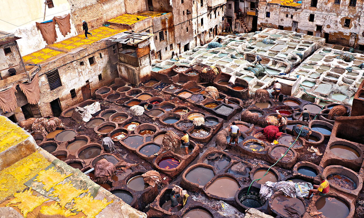
We visit the leather souks above the Fez River where, mint leaves pressed to our noses, Jess explains the centuries-old process taking place below us. Men in dye-stained shorts spend their lives washing, kneading and colouring fetid goat, camel, sheep and cow hides in huge open-air vats to transform them into Fez’s famed butter-soft leather, which is dyed with the likes of henna (orange), indigo (blue), cedar wood (brown), poppy (red) and saffron (yellow). And the secret to its suppleness: well, it’s the extra soaking in pigeon poo – whose ammonia acts as a softening agent – followed by kneading with bare feet.
Finally, Jess takes me to the Centre for Training and Qualification of Craft in Fez, set up by the King of Morocco’s Mohammed V Foundation. Here we watch young Moroccans learning ancient crafts such as carpet knotting, basket weaving, babouche making and plaster engraving. I buy gifts in the shop at fixed (and remarkably low) prices, knowing that all the money goes directly to the artisans.
I end my visit at Mike Richardson’s Cafe Clock, tucked in a 250-year-old former courtyard house behind the enigmatic thirteenth century water clock, whose mechanisms have been, rather appropriately, lost to time. With nfar trumpets used in Sufi music hanging from the ceiling and free wi-fi at its tables, Cafe Clock embodies the richness of Fez past and present.
“Music, art, faith and craft are intrinsically linked within the medina but often only within a familial environment,” says Mike. “I decided to create a fun and relaxed cultural cafe to meld the best of the best. Our ethos is that all can join in…at the cooking school, jam sessions, lectures, live concerts and film screenings.”
And they do. The night I’m there, gnaoua musicians play to a rapt audience, half comprising curious tourists, half locals. The young Fassi staff, their eyes bright with pride, dance with anyone who is keen. Everyone else is too busy eating Cafe Clock’s signature camel burgers, which, I admit, go down a treat.
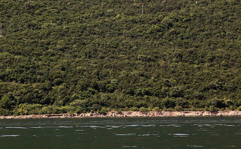
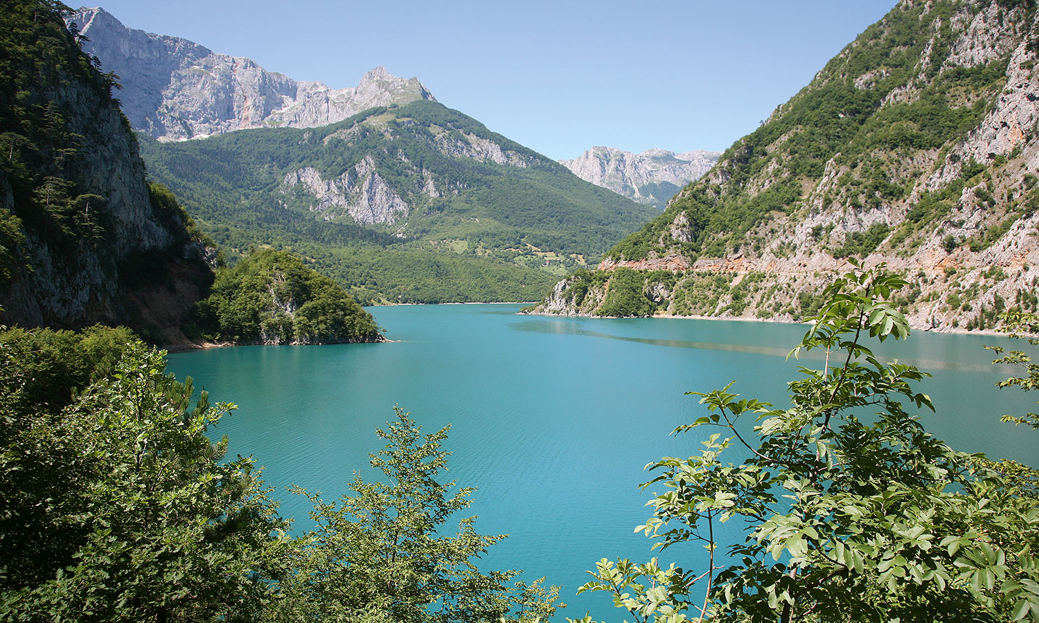
There’s not much hope of remaining inconspicuous when you’re bobbing around in a bright orange kayak on the Bay of Kotor. Montenegro’s UNESCO Heritage-listed bay, directly across the Adriatic from Italy and close to the Croatian border, has featured in a few tugs of war over the centuries, and the remnants of these conflicts are all around – although some are well hidden, unlike me. Fortunately it’s all quiet on the western front these days, otherwise I’d be a sitting duck.
Despite its often-troubled past, Montenegro is slowly emerging from the shadows of the former Yugoslavia as a proud and sovereign state, having gained full independence from Serbia in 2006.
In the same year, the country burst onto the big screen with a starring role in the movie Casino Royale. James Bond sped along the Budva coast in a speedboat, lost a lot of money at the casino (actually filmed in the Czech Republic but that’s Hollywood for you) and then went on his way: Montenegro instantly became synonymous with the high-roller lifestyle. In reality, the place is slowly catching up with its own image.
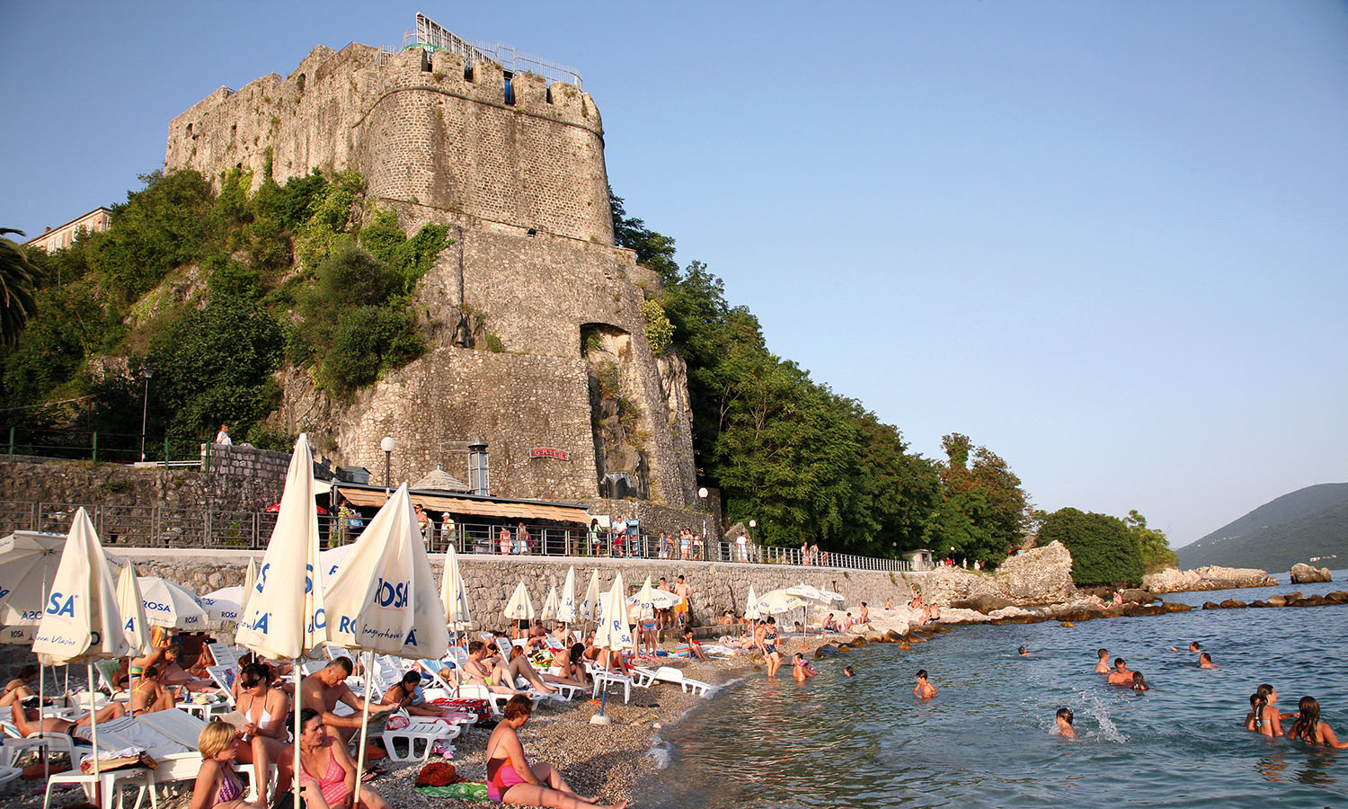
Herceg Novi is the first major town south of the Croatian border, and it’s from here that the Bay of Kotor opens up to reveal many secrets. Our first lesson in espionage is to look beyond the obvious.
Striking out across the ripple-free bay, we dodge yachts and fishing boats to reach Montenegro’s Lustica Peninsula. The crossing hasn’t always been such smooth sailing. Directly opposite Herceg Novi lies Prevlaka Peninsula, a highly strategic territory situated on the southern tip of the Croatian border, once the source of much dispute.
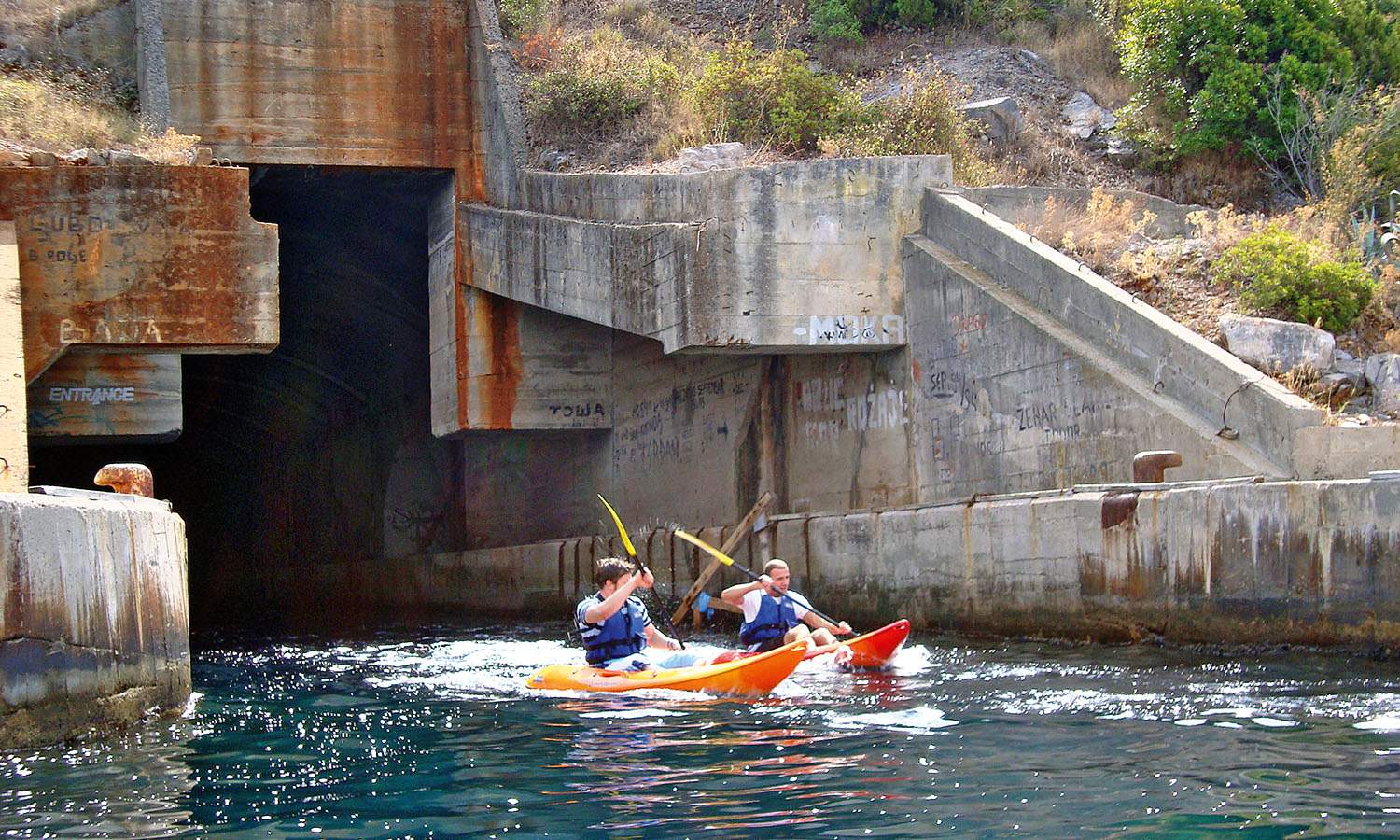
From the water, both sides of the bay look mild and innocuous. Until we spot gaping black holes cut into the cliffs, that is. Tito’s submarine pens are a sobering sight. The formidable President of the Socialist Federal Republic of Yugoslavia had tunnels chiselled out of the coastal rock face as a precaution against attack.
Cut into the coast like giant socket-holes, the holding pens are an eerie reminder of the days when this coast saw more soldiers than sun seekers and holiday-makers. The locals remember that era. Old men talk of summers spent learning battle techniques in the storerooms at the back of their shops – all part of their compulsory military service.
As I paddle into a submarine pen, the temperature drops as dramatically as the darkness descends. Straight away my sense of space disappears. Slicing a paddle through the dark is the only sign there’s water below. What else lies waiting beneath we don’t want to know. The guards and their guns are long gone, so hopefully the underwater war machines are too.
The pen runs about 80 metres into the rock. By day diving companies use it to simulate night dives and by night local teenagers bring in stereos and strobe lights for rave parties.
There’s plenty of space in here for a dance floor, but by torchlight the bare walls at the dead end of the tunnel have a sinister feel to them. We turn around and flee, with bubbles filtering up through the churning water as we speed out. Looking back you can’t see a single thing inside – this is definitely the place to disappear.
Stealth and camouflage are one thing, but the Montenegrins know how to stand their ground too. Our kayaking tour continues over open water to the abandoned Fort Mamula, built in the mid nineteenth-century by Austro-Hungarian general Lazar Mamula. The fort was once the country’s first line of defence, but it has definitely seen better days.
Last used during WWII (as an Italian prison, with a dark reputation), the cylindrical keep has certainly seen some action. Crumbling staircases climb only halfway up the curved walls, and scrambling up to the outer tower is an at-your-own-risk adventure. From the top, the fort splays out over the small island with 360-degree views of the bay, but there’s a minefield of big sinkholes in the floor. That doesn’t stop those boisterous teenagers of course – the fort’s large doors are kept well oiled by partygoers, and ash circles on the roof mark out the summer’s top bonfire sites.
It would be a lonely night on the fort with just the island’s resident big black rabbits for company, their huge yellow eyes observing you suspiciously from the dark. I pass on the opportunity. We didn’t bring enough supplies anyway, and the water levels in the man-made reservoir look to be dwindling.
Black Mountain, one of the only English-speaking tour operators in Herceg Novi, regularly plugs up the holes and commandeers the fort for survival sessions. They provide water, food and tents before setting groups against each other in night-time navigation games and team-building challenges.
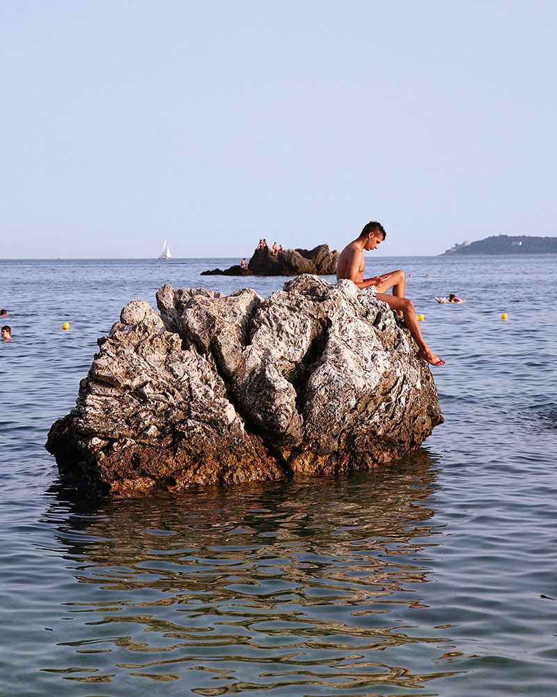
Spies are supposed to be made of strong stuff, and running around dodging sinkholes and giant rabbits sounds like it would toughen us up, but instead we go swimming off the rocks. Spiky sea urchins are danger enough for me, but at least the clear water helps keep those enemies in sight.
After a long day of exploring, the 3.4-nautical-mile paddle back to Herceg Novi is punishing. Ferries and fishing boats leave waves in their wake and our arrival into the bay is not accomplished with any kind of stealth – certainly nothing like the entrance James Bond made. We collapse on the pebbly shore for hard-earned cocktails – shaken not stirred.
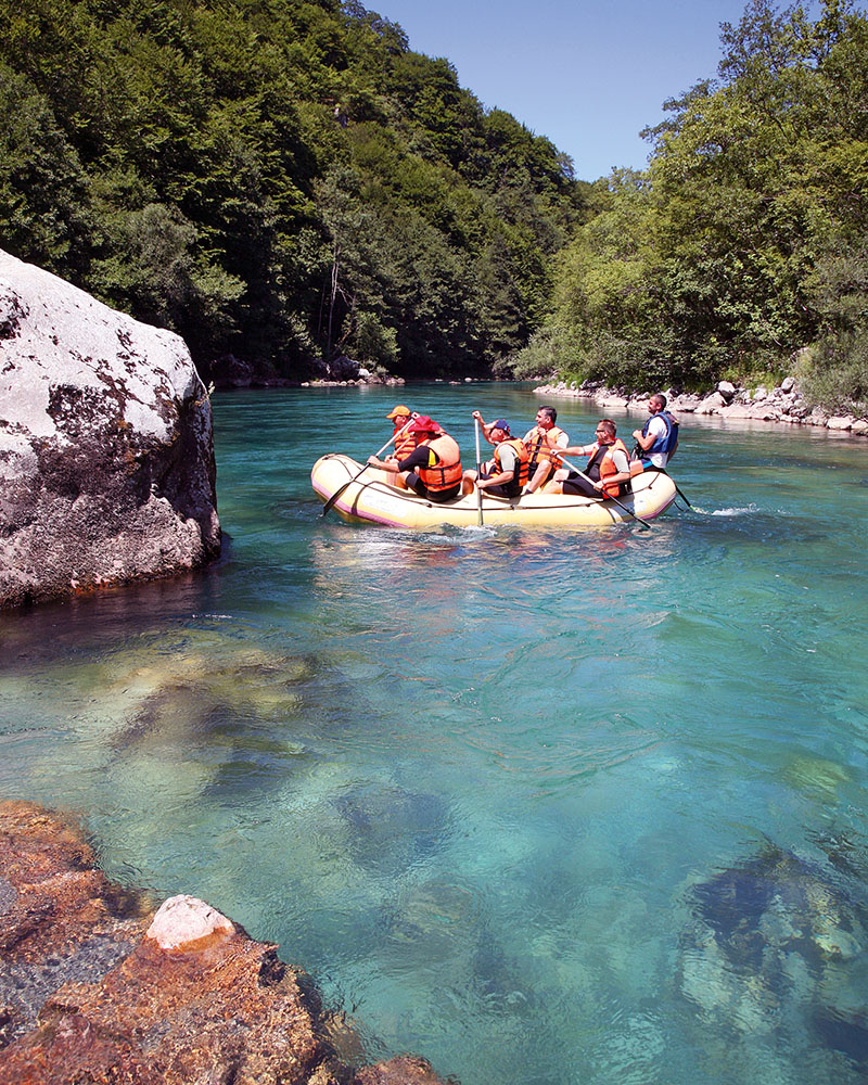
There definitely aren’t any cocktails on offer during our next aquatic challenge, when we navigate the foreign policy of border patrols during a whitewater rafting mission down the Tara River. High in the Durmitor Mountains of northern Montenegro, the waterway traverses the country’s border with Bosnia and Herzegovina, raging across a tangled knot of invisible political lines.
The adventure begins before we’ve even seen the river. Seven hours into a bumpy drive from Herceg Novi, our bus jerks to a halt. Two officers climb onboard, each yelling “passport, passport, passport”. We’re scrambling for our documents when a young man in khaki leaps on too.
“They go rafting, they go rafting, they go rafting,” he chants back at the men. It’s a battle of quick-fire words and emphatic gesturing – my only contribution to the charade is a paddling motion that earns no points.
Grabbed by the arm, I’m scooped off the bus and into a jeep, gaining political immunity by virtue of being a rafter. My bag gets thrown into the back and we’re off, not even stopping in at the border-control booth before veering onto a dusty road winding down the mountain. I later learn that we’d been at the Bosnian border stop at Scepan Polje, and I was effectively smuggled back into Montenegro after looping into Bosnia by a few metres.
Kamp Grab, a cluster of quaint wooden cottages and grassy campsites tucked into an old oak forest, sits in the foothills of the mountains. The river is a hint of sparkling azure between the trees.
The family friendly camp seems to be a popular stop on the rafting route – picnic tables at the cafeteria are full of people in half-zipped wetsuits. We meet Russians who like to jeer at their comrades coming down the river and cheerful Norwegian families on orienteering adventures.
In preparation for tackling the river, I first try to conquer the biggest ploughman’s sandwich I’ve ever seen, made by an old woman in the open-air kitchen, who saws off great chunks of bread from wheel-sized loaves. The bread comes straight from the wood-fire oven. Slapped between two pieces are slices of the region’s infamous Njegusi ham, cured high in the mountains at Njegusi. In goes sheep-milk cheese and a few slices of tomato. It’s a hardy meal and has me ready for an afternoon nap, not a roller-coaster run on the whitewater rapids.
But the rafts don’t wait, so I squeeze into my wetsuit and booties, jump back into the jeep and head to the flat, pebbled riverbank at Brstanovica. After a brief orientation from our Polish skipper (“Paddle forward when I say forward; paddle backwards when I say back”) we’re off. There are no straps or handholds, so my toes get wedged deep under the inflatable seat in front and I grip my paddle for dear life as we head through Europe’s longest canyon.
The Tara River Canyon takes up some 82 kilometres of the river’s 144 kilometre length, the rocky walls rising straight up from the banks. We bump and jolt through rapids, and several times get airborne after bouncing off the big boulders. About halfway through I remember to use my paddle.
The river runs fast and clear; you can see each pebble on the bed below when the water stops churning. A water snake cuts across the current, making the crossing to Bosnia without a second thought. In the silence after it slithers out of sight our guide tells us to watch the trees: “There’s men in the mountains over there,” he whispers. We’re floating down a natural border and at some points I could reach out and touch the Bosnian trees – but I don’t dare.
We pool into the shallows just below Kamp Grab, jumping into the icy water to scramble up the rocks. Hypothermia becomes the only danger now, but with wetsuits rolled down and hands warming by the bonfire, we’ve made our escape.
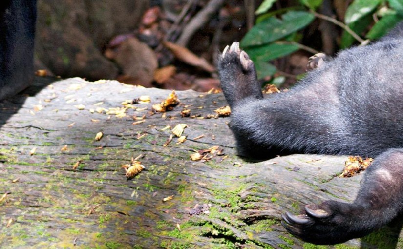
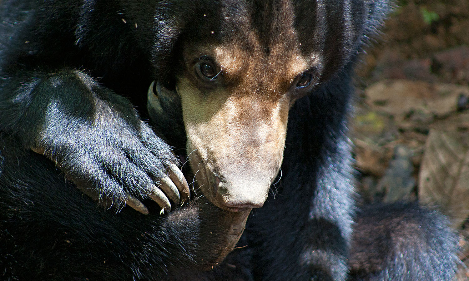
Mary is behaving, well, like a bear with a sore foot. She’s curled up on her haunches, foot in her mouth, suckling away on her claws like a frightened child. Her chestnut eyes are wary and timid, and when she stands her gait is askew, as though her legs aren’t quite up to the task of carrying her.
Mary is pining for her mother’s milk – a trait common in Bornean sun bears snatched or orphaned from their mothers. The nurturer in me wants to pick her up, envelop her in my arms, nuzzle her little pointy ears and play noses with her precious little snout. But Mary is a wild animal with fierce canines and elongated claws that could probably disembowel me in an instant should she feel threatened by my embrace.
In the steamy jungles of Borneo, in the Malaysian state of Sabah, Mary is the face of a burgeoning campaign to save this precious and little-known species. Victims of both their charms and their obscurity, sun bears have long been targeted by poachers and pet-pilferers; their numbers dwindling with their habitat, yet they’ve failed to register a blip on the international conservation radar. This is, after all, a region preoccupied with the beloved and endearing orangutan, the iconic and endangered ape whose plight has attracted a global groundswell of support.
But speak to wildlife warrior Siew Te Wong and he’ll tell you the sun bear’s survival is even more perilous – there just hasn’t been the investment in research to justify hitting the panic button. Wong founded the Bornean Sun Bear Conservation Centre in 2008 and is waging a public campaign to draw international attention to the loveable species and ensure their survival. He looks every bit the crusader primed for battle. When we meet he’s wearing army fatigues and a camouflage hat, and speaks with the fervour and urgency of a man who would rather be building fences and relationships with donors than talking to this traveller, who, it becomes clear, should have done more research before holding court with such wildlife royalty.
Wong is nonetheless generous with his time, and we park our behinds on a dilapidated wooden platform in the rainforest orangutans as he explains his passion for these curious animals. A few metres away, Mary continues to suckle on her right hind foot, a bear gnaws on a length of bamboo, others scratch and forage in the dirt and larger beasts slumber in the treetops, dangling precariously from spindly branches like soft toys displaced in a typhoon.
“Tell me they’re not cute, tell me they don’t deserve our protection,” Wong says, pointing to a sun bear lying prostrate on a log, head back, displaying the distinctive golden-coloured crescent of chest fur from which the bears get their name. “Look at that, basking in the sun,” he says, clearly besotted with his furry charges. They are indeed adorable, and I feel very privileged to be here. It’s hoped the conservation centre will open to tourists early next year, bringing much-needed income and exposure for the barrel-bodied bears. But for now, I’m the only visitor, enjoying this rare opportunity to see these protected and vulnerable creatures in the flesh.
Sun bears are native to South-East Asia and are the smallest of the world’s eight bear species, weighing up to 64 kilograms – smaller than a St Bernard. They have black, shiny pelts and extremely long, slender tongues that unfurl like party whistles for scooping up honey and insects. Like all threatened species in Borneo, they have been decimated by deforestation as more and more rainforest is swallowed by palm oil plantations, which have grown like a cancer over much of Sabah. Stripped of their natural habitat, the bears often wind up in plantations, where they are shot by hunters, poached for body parts used in traditional medicine (the gall bladder is particularly prized) or, in the case of cubs, snatched as pets. Confined to small cages and deprived of their mother’s milk, the cubs are malnourished and stunted when they arrive at the centre after rescue.
“I’ve seen so many bears in captivity, it’s dirty,” Wong says. “We have bears that look like dwarfs. They’re short legged – this is from malnutrition as well as growing up in small cages, which stunts their growth.” The hope is to rehabilitate the bears so they can one day be released back into the wild. But so far none of the 28 bears has been repatriated because it’s an expensive exercise and many are still incapable of surviving on their own. They will see out their days in the 2.5-hectare forest enclosure adjoining the popular Sepilok Orangutan Rehabilitation Centre, 25 kilometres west of Sandakan.
Visitor facilities are under construction at the centre and Wong hopes its unveiling to the public next year (2014) will give the sun bear campaign the impetus it needs. Sun bears are classified ‘vulnerable’ by the International Union for Conservation of Nature, but Wong says they belong on the ‘endangered’ or ‘critically endangered’ list. It’s estimated their population has decreased by 30 per cent in the last three decades and this decline will continue. With the region famed for its rich concentration of wildlife, it’s disturbing to learn that without intervention, one of Borneo’s most cherished creatures faces extinction.
Stirred by my afternoon with Wong, I travel deep into the Borneo jungle in an optimistic hunt for wild sun bears. I have the suspicion there’s more chance of spotting the Easter bunny lurking in the rainforest, but I’m determined to look. Leaving Sandakan, urban sprawl gives way to sprawling green – but it’s not rainforest hugging the road, rather palm plantations, almost as far as the eye can see. About two hours later, I arrive at Sukau in the Lower Kinabatangan Wildlife Sanctuary. Protected since 2003, the 26,000-hectare tract of rainforest has the highest concentration of wildlife in South-East Asia and forms a fraction of Sabah’s 3.1 million hectares of preserved, albeit fragmented, native forest.
It’s a short boat ride to my jungle lodge but long enough for swollen clouds to give way, administering a drenching in fitful bursts that lash my face. That night I sleep in a bungalow overlooking the river, surrounded by towering trees, heliconia and bird’s nest ferns. In the morning I wake to birdsong, slipping into the misty river just after dawn, with the jungle in full chorus. The boat putters along the Kinabatangan River (Sabah’s longest at 560 kilometres), the surface a glistening mocha fondant in the early-morning light under a sky of silvery sateen. An egret stokes the shallows, two brahminy kites swoop on unsuspecting small birds, catching them mid-flight, and a bunch of noisy proboscis monkeys scrabble in the branches. Their enormous, Gonzo-like orange noses are unmistakable, even as they leap from the branches in a boisterous acrobatic dance. The sun starts to colour the banks, thick with vines, tree roots and tangles of lush foliage, as we continue the forest rollcall of wildlife. Two oriental pied hornbill perch on naked treetop branches, a tiny blue-eared kingfisher hungrily studies the water and three silver-tailed monkeys sit silhouetted in the branches; their long tails dangling rigid-straight underneath them, making them look like stick puppets.
Then we spot the orangutans: a cluster of three and then two mature apes, their dark features and ginger cape of arm hair visible through binoculars as they grab fistfuls of leaves. “How can you tell it’s an orangutan from here?” I ask my guide Jame, who scans the rainforest with his naked eye like a brain surgeon studying a CAT scan, identifying unseen anomalies in the shadows. “He saw it darling, he’s my protégé,” Jame replies, attributing this particular find to our skipper. “We’ve been doing this for a long time, you know where to look.”
We motor into a small tributary and the banks contract like a verdant tunnel around us before funnelling the boat into a broader expanse of water, known as Ox Bowl Lake and named after the ox harnesses used for plowing fields. The ‘lake’ peters out in a strangle of floating hyacinth and water spangle, our cue to turn around and head back. I’ve seen many animals, but no sun bears. It’s not surprising. In 16 years plying these waters, Jame has only spotted one solitary bear. I hope with optimism that out there, somewhere in the wild, the dense jungle is harbouring scores of Mary’s relatives, tucked away safe from prying eyes.
Back in Sandakan I feel like a fish out of water returning to the compact city centre, squeezed between the rainforest and the sea. I stroll through the grubby backstreets and wander through the Sunday market, chatting to inquisitive locals along the way. “Where are you from? You see the orangutan?” they ask. “Yes,” I reply. “I saw the sun bears too.” My comments are met with frowns and disinterest. Clearly Wong still has a way to go in educating the public about these charismatic beasts.
Standing in central Macau and contemplating your surroundings involves sustaining an assault on at least two of your senses. Within seconds of leaving your air-conditioned hotel the humidity seizes you in a sticky embrace, and your eyes are bombarded by a synthetic, ultra rainbow of multicoloured lights and neon imagery that erupts in waves across the claustrophobically clustered cityscape. It’s as though you’ve stumbled into the guts of a giant slot machine.
And this is precisely what most people expect of this SAR (Special Administrative Region) of China – that it’s an enclave of excess on the doorstep of the world’s biggest supernation: an Asian Vegas on an outstretched limb of China, that is literally swelling as the number of casinos it hosts continues to grow.
But this is only one face of an astonishingly diverse destination. With its Portuguese heritage, perfectly preserved Old Town areas and population of tai-chi practising locals who have been here far longer than the modern gambling dens, Macau holds more than a few surprise cards up its sleeve.
If you’re indifferent to the come-hither power of the casino’s winking electric eyes, and you demand more from a night out than a few imported beers in a sterile bar with false lights and no clocks, we suggest spending the day exploring the temples, parks and streets of the islands of Taipa and Coloane, before working your way back to the peninsula via some of Macau’s more interesting watering holes and feeding stations. By the time you get back downtown, you may be in the mood to dig a bit deeper into what really lies behind those lights.
5.15pm
Start by lining your stomach with a couple of Portuguese egg tarts from Lord Stow’s Bakery in Coloane Village. Englishman Andrew Stow went up to the big bakery in the sky a few years ago, but his legacy lives on thanks to his now iconic interpretation of these classic pastries (pies that became so legendary they got him onto Macau’s new year’s honours list). It’s tempting to tuck into a baker’s dozen of these melting mouthful-sized tarts, but pace yourself – eating is a central part of a night out in Macau, and there’s plenty more to come. Lord Stow’s Bakery 1 Rua da Tassara Coloane Town Square lordstow.com
5.30pm
Wash away the crumbs by pouring a couple of bottles of ice-cold Macau Beer down your pie hole, while sitting around a table in the neighbouring market. The service is reassuringly rude at joints such as Nga Tim, so you know you’re getting the real deal and not the tourist treatment, and the whole square is as chaotic as it is aromatic. Sip your beer and slurp down the atmosphere while surrounded by cacophonous locals scoffing supper as the sinking sun turns the Chinese mainland into a silhouette across the water. Menus are full of seafood dishes cooked in a mixture of Macanese, Portuguese and Chinese styles – from ‘sauna prawns’ to curried crabs – but restrict yourself to a few light nibbles as an appetiser, then jump in a cab. Nga Tim 1 Rua Caetano Coloane Town Square
6.00pm
Arrive at Miramar Restaurant, which has outdoor seating overlooking Hác Sá Beach and is a top place to continue your sundowning. This Portuguese place has been bashing out classic cuisine since before the 1999 Macau handover, and the charismatic and matriarchal chef, Rosa, does a mean galinha á Africana (‘Africa Chicken’ – a local Macanese recipe that has absolutely nothing to do with Africa), as well as a fine garoupa (white fish) dish and an epic serving of a meal that involves a suckling pig stuffed with rice. Plates are generous here, so order a big ice bucket full of Super Bock (Portuguese beer) to keep you lubricated between mouthfuls. The wine list is comprehensive too – with its Portuguese history, Macau is one of the few places in Asia where wine is truly appreciated. It’s difficult to avoid eyeing the cake counter – lined with towering variations of Macau’s signature dessert, a simple but seductive sweet made from cream and crushed biscuits called serradura (‘sawdust’, because of the powdery biscuits) – but try and restrict yourself to a small serve as there’s more belt-loosening activity ahead. Miramar Restaurant Zona Norte da Praia de Hác Sá Coloane miramar.com.mo
7.30pm
Moving away from the greenery of Coloane, toward the busier streets of Taipa, you’ll cross the Cotai Strip, an area of reclaimed land that now joins the two islands. This is home to the Venetian (where you can take a gondola ride along a canal, complete with a big-lunged gondolier from the Philippine Opera Company), the Galaxy and the City of Dreams – all behemoth hotel, casino and entertainment complexes. The latter houses three hotels – including the Hard Rock, where you can hire a suite complete with a round, padded room containing a rodeo machine. To sup with the high rollers, head to Belon in the Galaxy’s Banyan Tree for a glass of fine wine, hand-picked by Jeannie Cho Lee, Asia’s first Master of Wine, or introduce yourself to the mixologist at the City of Dream’s Flame Bar and pucker up for every pyromaniac’s preferred poison, a Solar Flare, or perhaps even a drop of Marie Laveau’s Voodoo Brew. Cotai Strip Macau venetianmacao.com galaxymacau.com cityofdreamsmacau.com
8.30pm
Time to park your arse, give your mouth a rest and your body a chance to digest some of that bounty, as your eyes take in a show. Macau might not have the variety of visual entertainment that Vegas boasts, but in the House of Dancing Water it does have a unique and astonishing show that will blow the cynical socks off even the biggest of theatre-phobes. Staged in a purpose-built performance space above a complicated and ever-transforming water pool, and involving everything from finely choreographed dancing and fighting scenes, right through to high-diving daredevilry and Crusty Demons-style motorbike stunts, it pretty much has something for everyone – although just watching it may give you indigestion. thehouseofdancingwater.com
9.30pm
Despite the looming presence of modern money-spinning monsters nearby, historic Taipa Village remains a charming little spot with European-style alleyways running through it like tunnels in a rabbit warren, restaurants and bars buzzing with activity and local families mingling with visitors on lantern-lit cobblestone streets and piazzas. António, right in the belly of the village, is a spectacular place to experience Asian Portuguese cuisine at its finest, with Michelin-starred chef António Coelho driving both the saucepans out the back and the atmosphere in the front of this intimate and welcoming restaurant. António also has a little bar opposite his restaurant on Rua dos Negociantes, which is great for a pre-dinner drink and where – particularly if you’re a lady – he’s been known to demonstrate how to open a bottle of champagne using a sword. The menu is enormous, but if you can’t do justice to the bacalhau (a dish made from dried, salted cod) or the camarão tigre grelhado (giant tiger prawns), perhaps settle for something lighter, like honey-fired goat cheese on truffle toast with some house-cured olives, and chase it down with a few glasses of vino verde (a bubbly green Portuguese wine that’s well loved in Macau). For dessert, don’t miss out on the dramatic flaming crepes suzette, which António makes in front of your table – as much a spectacle as it is a dining experience. António 3 Rua dos Negociantes Old Taipa Village Taipa antoniomacau.com
10.30pm
Just down the road from António’s joint is the Old Taipa Tavern. Taipa is where most of Macau’s expats base themselves, and this pub is a classic British-style boozer where many of them come to sip pints. It’s not a god-awful theme pub though, it’s a genuine alehouse in the midst of Asia, with a convivial atmosphere inside and pavement seating outside. Down a pint of Guinness here while you wait for a cab. Old Taipa Tavern 21 Rua dos Negociantes, Old Taipa Village, Taipa 11.15pm Bolt back across the bridge to the bright lights of the peninsula, where the skyline is dominated by the Macau Tower. AJ Hackett offers the world’s highest bungee jump (233 metres) from the top of this tower, and you can even take a leap at night – although perhaps not after such a bellyful of booze and bacalhau. AJ Hackett Macau Tower macau.ajhackett.com
11.30pm
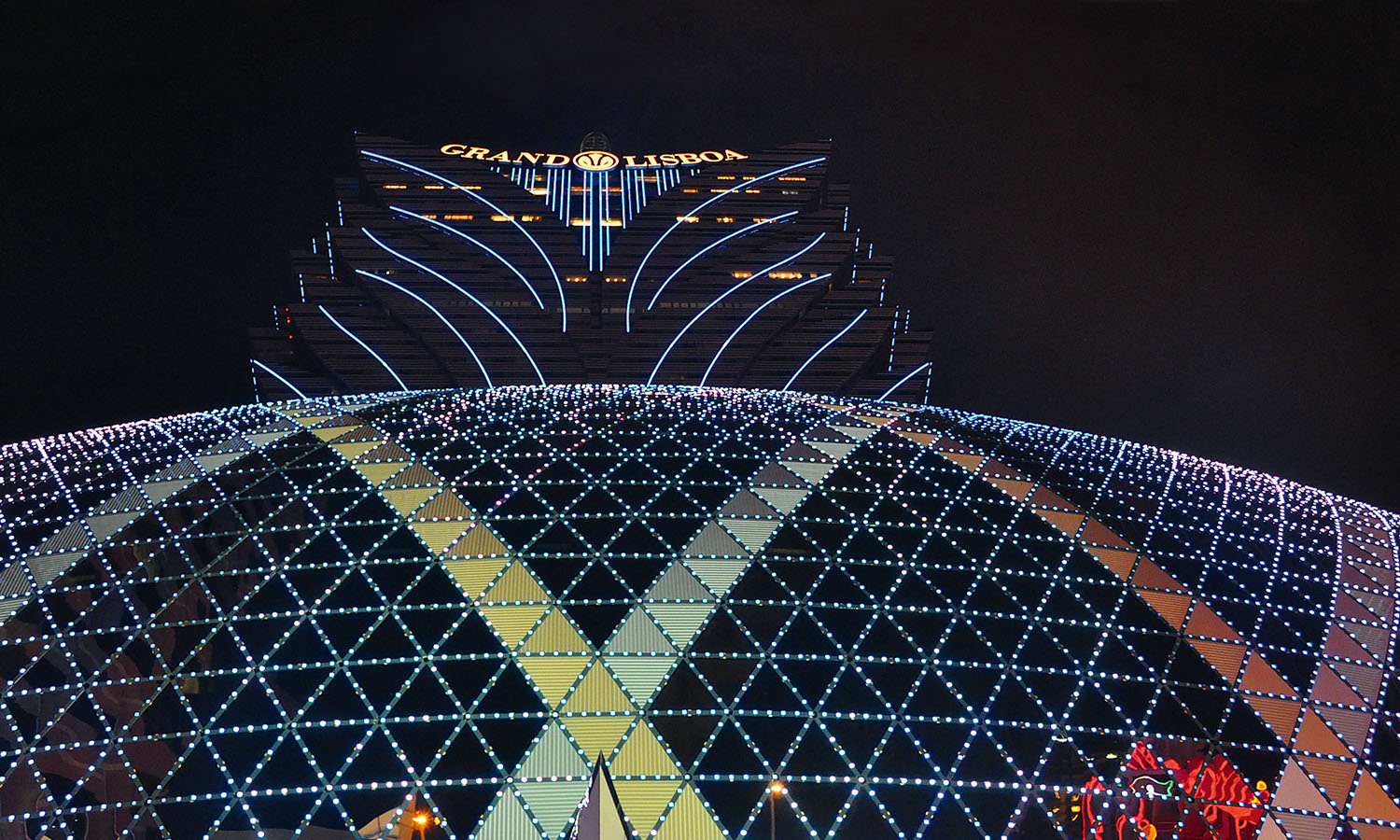
Hop out of the taxi at the tower of tackiness that is the Grand Lisboa and have a wander through the gaming floors of one of Macau’s classic gaming houses – even if it’s just to gawp at the surreal spectacle of it all. In just a decade, Macau has been transformed by the casinos, which have been turning over more coin than Las Vegas since 2006 and now make at least US$14 billion a year. The casino culture is quite different here though; the (predominantly Chinese) crowd takes their gambling very seriously, and there’s not much bucks’ night frivolity in evidence. The on-table action differs too, with local games like sic-bo, fantan and pai-gau being played alongside baccarat and roulette. If you don’t feel like losing any money, there’s plenty of opportunity to spend some too – choose from one of three Michelin-approved restaurants that this building boasts (including the jewel in the crown, the uber fancy Robuchon au Dôme), or grab a pick-me-up glass of chilled vodka in the Lotus Lounge (thanks to the influx of cashed-up Russians, the selection of exquisitely distilled potato juice is startlingly good). Grand Lisboa Avenida de Lisboa, Macau grandlisboa.com
12.00am
A short walk away is one of Macau’s hidden nocturnal gems. Sky21 is a surprise bar perched on the 21st floor of the ever-so-corporate-looking AIA Tower, with an outdoor mezzanine level offering an amazing alfresco drinking experience with a view right across the peninsula and into China. DJs tickle your ears with cruisy tunes as you sip cocktails or beers, and the gentle lighting and classy-but-cool ambiance is a world away from the insanely illuminated mercenary madness of the gambling dens below. Slightly incongruously for such a trendy joint, there’s also a dart board (albeit an electronic one). Open late, this is a cracking place to wind the night down, but if you’re still amped for more action, one of Macau’s best clubs is just downstairs. Sky 21 Level 21, AIA Tower Avenida Comercial de Macau (opposite the Grand Emperor Casino, take the lift next to Starbucks) sky21macau.com
2.00am
At D2 you can shake away some calories ingested earlier to the tunes of the best local DJs or visiting Russian turntable tsars. On a good night it stays open right through until 6am, when you can wander back through the city’s parks, past the swaying army of tai chi practitioners and caged-bird walkers that meet the dawn each day. D2 Level 2, AIA Tower Avenida Comercial de Macau d2club-macau.com
With 18 official religions, Lebanon and its vast cultural and ethnic diversity has historically been a recipe for civil unrest. Now, one charismatic Beiruti is nurturing his country’s shared love of food to promote reconciliation in the Middle East’s most diverse nation.
I meet Kamal Mouzawak at Tawlet, on the edge of Beirut’s Bourj Hammoud Armenian district. While gentrification is starting to take root in the city, the eatery sits amid gritty tyre-repair shops and smoky wood-fired bakeries that turn out Lebanon’s iconic flatbread, manoushe.
Mouzawak’s vision to create food that transcends cultural barriers is reinforced in Tawlet’s welcoming interior, which is more trendy Melbourne than troubled Middle East. Tawlet means ‘kitchen table’ in Arabic, and Mouzawak uses the universal pleasure of eating to bring people together, irrespective of their cultural, political or ethnic backgrounds.
“It’s not just the food that’s important,” he explains. “But it’s the getting together and the sharing of this food that’s important for the future of the country.”
Every weekday a different chef from across Lebanon prepares a buffet lunch, drawing on their own history, traditions and hometown flavours. Each of Tawlet’s 30 village cooks, shepherds or traditional farmers travels to Beirut for one day a month, often bringing their meals’ ingredients from their own gardens and small holdings.
Traditional flavours and local dishes, once threatened by conflict and cultural diaspora, are shared and celebrated. And the skilled cooks, whom Mouzawak calls producer chefs, enjoy the exposure.
“Yes, they are peasants and farmers, but they’re doing something just as important as anyone else,” Mouzawak says. “They get all the economic benefits and have direct access to consumers.”
Today’s chef is Oum Ali, a Muslim mother from the South Lebanon village of Majdelzoun, near the Israel border. As her son completes his homework, Ali commandeers the open kitchen to prepare lunch. Tawlet’s onsite cook and waiters drift in and out, communicating in a cosmopolitan patois incorporating Arabic, French and even the occasional English word.
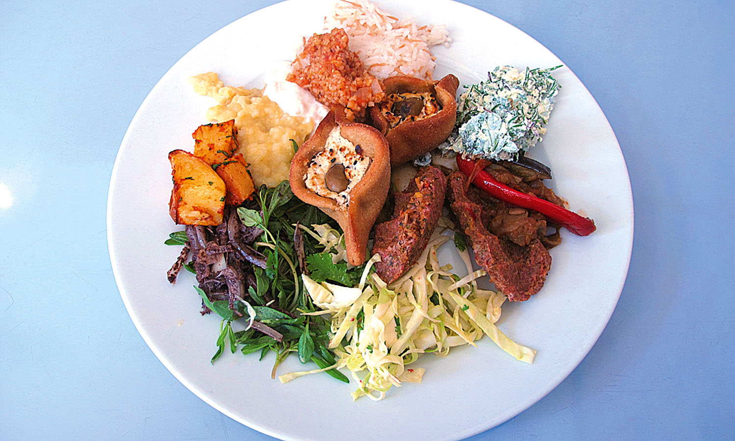
Her hands produce perfectly compact torpedoes of frakeh, spicy raw lamb blended with burghul wheat and spices, including cinnamon, cumin and marjoram. Fatayer pastries stuffed with sheep’s cheese and olives form mini-mountains of golden baked goodness, and abundant salads are studded with mint, thyme and a zingy sprinkling of sumac.
Laban emmo, a succulent dish of lamb in yoghurt sauce, is prepared, and young wheat is roasted and grilled with chicken for a robust bowl of frikeh djeij. It’s all incredibly authentic, packed with flavour and light years from the identikit shawarma, hummus and baba ghanoush served in most Lebanese restaurants in Australia. A pale ale infused with za’atar – Middle Eastern herbs, including sumac, mint, sage and anise – by Beirut’s 961 craft brewery is a surprising adjunct to some of south Lebanon’s most traditional recipes.
Mouzawak passionately regards Tawlet as much more than a restaurant. “It’s a farmers’ kitchen,” he gently corrects me when we first meet. The eatery follows another remarkable project he established in 2005.
Souk el Tayeb operates under the banner Make Food, Not War, and is Lebanon’s first farmers’ market, held weekly near the ritzy Beirut Souks shopping area in the city’s rapidly re-emerging downtown precinct. Every Saturday morning the market brings the country to town, showcasing about 45 different stallholders from all around Lebanon. Eight years since its beginning, promoting the United Farmers of Lebanon, the Souk el Tayeb is a Beirut institution, even trading through the dark days of the 2006 Lebanon-based conflict between Hezbollah and Israel.
About 90 per cent of Tawlet’s chefs are also regular sellers at the market, where Palestinian, Muslim, Druze and Christian producers showcase their artisan products and traditional foods, side by side in a location that was once the epicentre of civil war.
Dressed in his traditional garb of black baggy trousers, stallholder Hussein Abu Mansour from a Druze village in the Bekaa Valley has zesty fruit pestil and zingy glasses of grape and pomegranate juice. Suzanne Doueihy from the Christian Maronite town of Zgharta, in northern Lebanon, is the country’s acclaimed Queen of Kibbeh, and her baked dish of kibbeh bi labneh layers ground lamb with yoghurt and pine nuts.
Armenian dishes from Beirut’s Sona Tikidjian include lahme bi ajine, a spin on lahmacun or Turkish pizza, while Maurice Habib’s fragrant honey is from Lebanon’s famed cedar forests.
I also catch up again with Oum Ali from my lunch at Tawlet a few days earlier. She’s a regular at Souk el Tayeb, and her ongoing appearance at the market enables her to put her family through school.
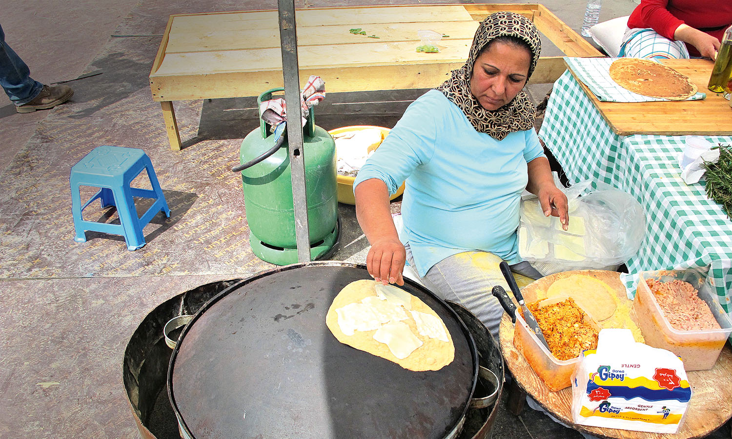
Ali gives me a shy smile as she sits at her saj, a convex-shaped griddle. She scatters a robust portion of chilli-laced labneh cheese onto the unleavened manoushe wrap she’s just prepared, folds it gently, and carefully presents my order wrapped in newspaper. Along with an organic espresso from an adjacent stall, it makes for a perfect brunch in a surprising city.
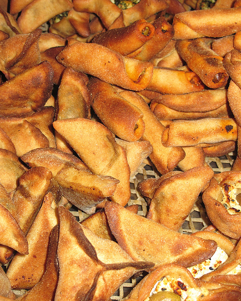
Fatayer are small savoury pies and can be made in different shapes and sizes and with different fillings. This recipe uses spinach seasoned with lemon and sumac, and is known as fatayer bi sbenegh. They’re normally served as part of a mezze selection with other traditional Lebanese small plates.
INGREDIENTS
500g flour (white flour or a mix of half white and half wholewheat)
1 tsp yeast
1kg spinach, finely chopped
1 tomato, finely diced
2 tbs sumac
1 tsp lemon juice
2 onions, finely chopped
METHOD
Knead the flour with enough water to form a dough. Dissolve 1 tablespoon salt and the yeast in tepid water, and add to the dough. Roll the dough into a ball, place it in a bowl, cover with a tea towel and leave to rest for one hour.
To prepare the filling, combine the spinach and tomato. Combine the sumac and lemon juice with the onions then add to the spinach and tomato. Season to taste with salt and pepper.
Preheat the oven to 210ºC.
Roll the dough thinly and cut in circles around 10 centimetres in diameter. Check the filling to make sure it isn’t watery (you can squeeze out any excess moisture with your hands). Place a tablespoon of the filling in the centre of each circle of dough. Fold the dough in from three edges to form a triangle, and pinch to seal. Put each fatayer on a lined baking tray and cook in the oven until golden. Leave to cool and serve cold.
This recipe is courtesy of Kamal Mouzawak, founder of Souk el Tayeb and Tawlet. soukeltayeb.com tawlet.com
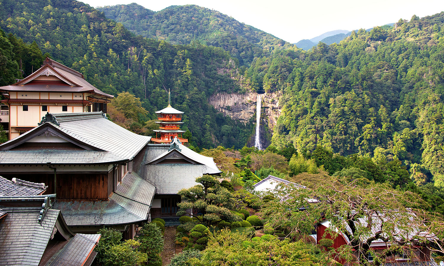
Ryoei Takagi is a 62-year-old Buddhist monk. Every January he climbs the steep snowy slopes of his home in the Kii Mountains of Japan to meditate under the 48 sacred waterfalls that flow into the Nachi Otaki – the tallest waterfall in the country, revered in folklore as a living god. Despite the icy conditions, he’s able to remain submerged in the near-freezing flow for 45 minutes at a time. “This training has granted me supernatural powers,” he says, leaning in to whisper in my ear. “I can see people’s heart inside.”
But subjecting oneself to glacial conditions, he explains, is only a small part of the process. The real business is in the mountains. Takagi is a follower of Shugendo, an ancient Japanese religion that fuses Buddhist ideals with indigenous forms of nature worship. For centuries, devotees like Takagi, known as yamabushi, have been trekking Kumano’s arduous slopes in the belief that ascetic training in sacred spots can grant one magical abilities. Japanese folklore is rich with examples of these mountain monks predicting the future, walking on fire and even flying.
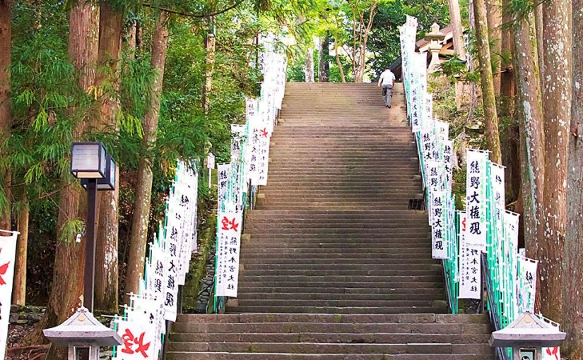
I’ve come to Japan to explore these sacred mountains. I want to learn more about Shugendo and perhaps see if some of that magic will rub off on me. Over the next five days I will be walking the Nakahechi section of the Kumano Kodo – an 88-kilometre ancient pilgrimage path that bisects the Kii Mountains in the Kumano region of the Kii Peninsula, 200 kilometres south of Kyoto.
For more than 1,000 years emperors and peasants have been walking these trails in search of enlightenment and healing on their way to the three Grand Shrines: Hongu Taisha, Hatayama Taisha and Nachi Taisha. Mirroring their journey, I plan to stay in small mountain villages just off the trail and discover, I hope, a slice of rural Japanese life seldom seen by outsiders.
“Walk the route, breathe the air and make room in your heart to feel it,” Takagi tells me. If there is such a thing as hiking nirvana, then the Kumano Kodo is surely the place to start looking.
Japanese emperors would have started their journey in Kyoto, with royal processions – sometimes 800 strong – inching their way 160 kilometres south to the port of Tanabe before turning east towards the mountains. But for me the trail begins a few miles inland at Takijiri-Oji, the gateway shrine to the sacred lands of Kumano, and once the site of great celebration and ritual offerings of poetry, dance and even sumo. From here I climb five steep kilometres to the mountain village of Takahara, passing monoliths with mantras etched in stone, buried sutras scribed by emperors, and small wooden shrines with offerings left inside: cups of green tea, a red blanket, rusting decades-old coins. It’s like entering a living museum.
That evening owner Jian welcomes me to the Kiri-no-Sato guesthouse with a banquet of traditional Japanese country cooking known as kaiseki – dozens of individually prepared, uniquely flavoured dishes – that I encounter many times on this trip. Tasting steamed mountain vegetables – along with tuna sashimi, salmon teriyaki, venison in spicy miso sauce – parts of my mouth that had been bone-idle since birth suddenly start singing karaoke. Seeing my reaction Jian smiles. “This is the idea of wabisabi, and it’s how you should walk the Kumano Kodo too: with all your senses open and in the moment.”
I leave for Chikatsuyu, 10 kilometres east, at dawn the next day. The clouds are still sleeping beneath terraces of rice and soya bean and the mountains are two-toned dark green and misty grey. This small valley town, bisected by the Hiki river, has been used as a stopover since the time of the first imperial pilgrimage. Even in the depths of winter, devotees would immerse their entire bodies in the freezing mountain water to purify themselves of sins and misfortunes. Luckily for me my guesthouse, the Chikatsuyu Minshuku, is the only one in town to pump this sacred spring water through a heating system and into a bath right on the river. As I lie in the steaming pool two eagles soar on thermal currents above the gentle rapids at the edge of the tub. I’m not sure if this counts as Shugendo mountain training, but it feels pretty enlightening to me.
Despite its antiquity, the Kumano Kodo has in many ways always been the most progressive of Japan’s sacred places – welcoming all, irrespective of gender or class. As a result it’s been popular too. Records refer to a ‘procession of ants’ – hundreds of white-clad pilgrims scrambling up the steep slopes.
As I walk to Hongu Taisha the next day, climbing 25 kilometres of mercilessly steep mountain passes, I feel tiny, beat up and exhausted. “Being in nature makes you humble” Takagi had told me. “That’s why we come here for training.” Now I understand what he meant; there is nothing more ego-levelling than walking in steep mountains. But despite the exertion, gradually a peacefulness descends on me too. The muted tones and slatted bark of the forest seemingly mirrors all thought, and contains all sound.
When finally I stumble into the dark, natural wood buildings of Hongu Taisha that evening I am greeted by a deep roll of thunder so sonically low it seems more imagined then real. Surrounded by cicadas and the golden lanterns, curved cypress bark roofs and hollow ritual bells of the shrine, I watch eight drummers beat deep taiko drums with thick wooden sticks. They play with such raw primal energy and intensity of focus it feels as if the music and the drummers are one entity – a contained ferocity that seems to emanate from the mountains themselves. It’s mesmerising.
From here pilgrims would traditionally follow the Kumano-gawa river to the Grand Shrine of Hatayama Taisha, but I press on to Yunomine – the only UNESCO World Heritage listed hot spring on the planet you can actually bathe in. Founded 1,800 years ago, it’s also the oldest in the country and, at a scorching 34°C, one of the hottest too. But that’s not all. As I stroll through the village I notice an old man with rubber gloves hoisting something from a hole of simmering water in the central square. To my great surprise a bag of sweet potatoes and a dozen perfectly hardboiled eggs emerge at the end of the line. Not only can you get wet, you can cook your dinner here too.
In 2004 the Kumano Kodo pilgrimage was granted UNESCO World Heritage status, and my final two-day trek to Nachi Taisha takes me through some of its most beautiful scenery. I walk miles of mossy stone paths that wind through bamboo and cedar forests like entrances to an enchanted kingdom. I pass statues of dragons, monks and emperors, and giant cedar trees with hollowed out roots and offerings left inside. I follow rivers and ridges into valleys and villages where wildflowers – planted centuries ago in case of famine – still bloom peach, yellow and blue, and where shy farmers string up hay, like dolls’ hair, to dry in the sun. I hear the snort and dash of a disappearing deer. I eat fresh river crab and – during sunset at Hyakken-gura lookout, the most sublime panorama of the entire trip – I picnic on a Yunomine hot spring hardboiled egg, the best I’ve ever had.
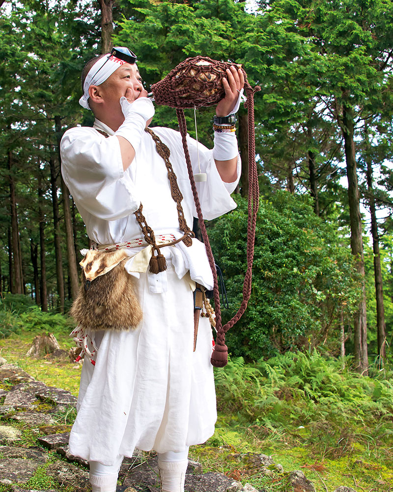
Then, as I catch my first glimpse of the Pacific Ocean – knowing the end of the pilgrimage is now in sight – something amazing happens. I hear a sound like nothing I’ve encountered before: the soft howl of an animal, but earthy too, like wind through bamboo. There in immaculate white suzukake robes (ritual garment), with bound feet, straw sandals and a conical Minachigasa cypress hat, is a real life Shugendo yamabushi. He stands tall and proud on the last summit ridge and blows his traditional hora conch shell trumpet to the wilds – signifying the teachings of Buddha and the summoning of nature’s deities. It lasts only a few moments, but listening to him play is the highlight of my trip.
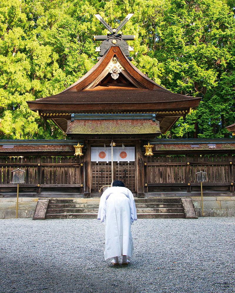
At the end of my journey I walk through the cedar wood incense and the cherry trees of the Grand Shrine of Nachi Taisha – a soft soprano prayer echoing from behind temple walls – to the Nachi Otaki cascade nearby. Shugendo is a unique form of Buddhism, in that it stresses the attainment of enlightenment through active immersion in the natural world. Staring up at the 133 metre falls it occurs to me that there is a profound common sense in that idea.
For most of our existence, we human beings have been actively and intimately connected with nature. It shaped us and it’s part of what we are. If enlightenment is to be found inside us, perhaps it makes sense to start looking outside first. I walk down to the base of the freezing waterfall and think about jumping in. But only for an instant. I think I’ve been enlightened through immersion enough for one day.
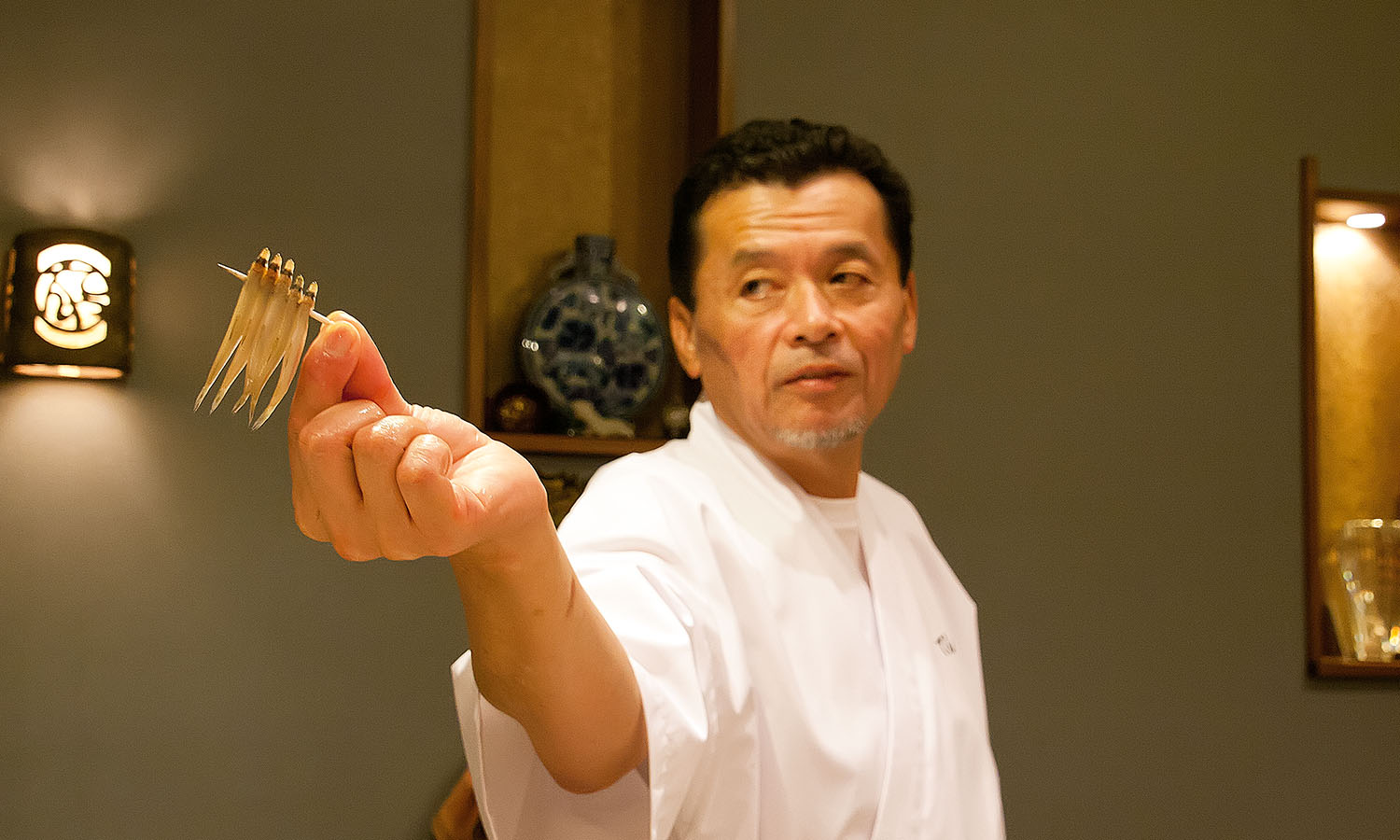
On the face of it, tempura sounds like a euphemism for a Japanese fry-up. The kind of coronary cyanide proffered by fast food joints, whose culinary imaginations know no bounds when it comes to what can be slathered in batter and blasted in the deep fryer.
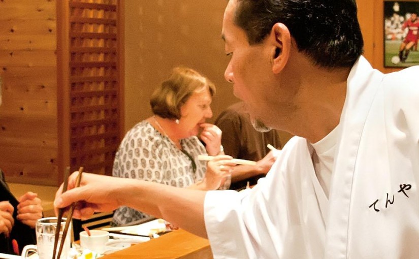
Tempura uses the same staple ingredients as the great Aussie piece of fish – bubbling hot oil and batter – but the end product is far more delicate and wholesome than the corner fish and chippery. And tempura sensei Sho Ichi Okawa is no harbinger of heart attacks; rather, he’s an artist whose crunchy creations play to the palates of the discerning diner.
Sho is the owner chef of Tenya tempura bar in Kashima City, a waterfront town in Ibaraki Prefecture, about 85 kilometres east of Tokyo. For three decades, Sho has been serving up tempura – lightly battered seafood and vegetable parcels – to locals and foreigners who arrive in numbers on the docks at Kashima port. Sho’s place is the only bar-style tempura restaurant in Kashima, a city famous for its Jingu Shinto Shrine and the Kashima Antlers football team, of which he is a fervent supporter and sponsor.
Sho’s love affair with food started as a teenager, when he cut his chef’s teeth in a French restaurant, before being introduced to traditional Japanese cuisine in Tokyo’s vast food dens.
“I was so much surprised to see how excellent the Japanese dishes were,”
Sho says through an interpreter, gesticulating with chopsticks to make his point. But tempura is “number one”, he adds, pointing to his heart through a crisp, white hanten (traditional Japanese winter jacket). “Tempura is legendary, traditional cuisine – I am proud of it.”
Traditional it may be, but native to Japan it’s not. Tempura is a culinary import, introduced by Portuguese missionaries in the mid-sixteenth century. It has since become a favourite at kitchens, yatai (street vendors) and restaurants across the island nation.
At Tenya, tempura is as much about theatre as it is food. Here you can sidle up to the bar, slurp on an Asahi and eyeball Sho as he whips up a veritable degustation of crisp, battered goodies. He engages the kitchen in a sizzling chopstick dance, like a conductor whose orchestra comprises veggies and crustaceans.
I start with a plate of sashimi, a dish that’s synonymous with Japanese cuisine, tucking into slivers of fleshy tuna, yellowtail and mackerel that is so tender in almost melts in my mouth.
Next there’s mushroom pudding, a velvety custard concoction made with shiitake mushrooms, chicken, shrimp, blended fish and bamboo, and steamed in a ceramic pot. There are ginkgo nuts with curry salt, boiled peanuts and isobe maki (fermented soybean wrapped in seaweed). Each dish serves as an appetiser to the main event – a seemingly unending procession of tempura dipped in batter using a pair of deftly handled chopsticks, poked in hot oil and deposited in a basket in front of me at the bar.
I gorge myself on sweet potato and ginger parcels encased in wafer-thin bubbles of salted batter, and pick at a whole barracuda staring blankly at me. Next there’s tempura asparagus, wakasagi (tiny fish threaded on toothpicks), maitake (‘dancing’ mushrooms), and voluptuous orbs of runny egg yolk that come from chickens fed sesame and vitamin E to make their yolks big and round.
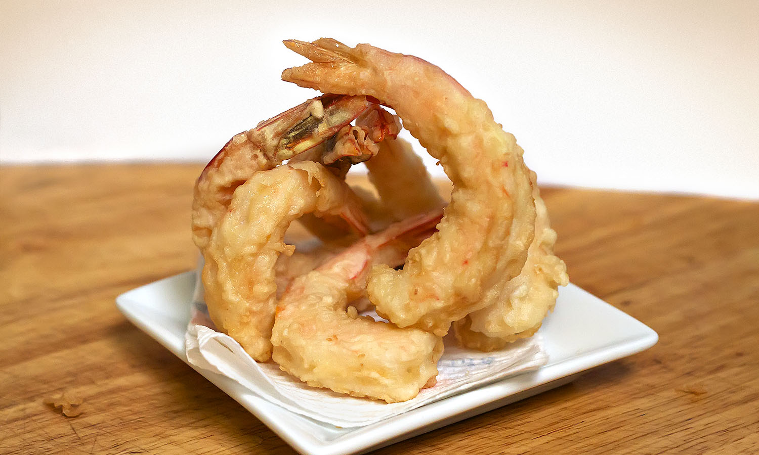
Finally, the pièce de résistance: tempura prawns, delicately crunchy on the outside, with plump, juicy-sweet flesh on the inside. The feast is washed down with more beer and lashings of sake.
It’s clear Sho likes an audience, and before the meal is over he scrunches up a handful of prawn shells, dips them in batter and tosses them in the oil. They crackle and hiss like pee on a fire and come out golden and crisp. I’m stuffed but don’t want to disappoint my host, who grins like the Cheshire Cat as I nibble at the edges of a piece of shell, which is edible but not a patch on his earlier offerings.
Sho opened his restaurant 30 years ago but didn’t specialise in tempura until eight years later, at the behest of his loyal patrons. His tempura is such a hit he plans to teach his skills to chefs in Sri Lanka.
“I think now it’s a good choice I made, doing tempura,” he says. “I think cooking is, in a sense, a kind of art.”
Indeed. And Sho must surely be one of the best artists around. And there’s not an ounce of fat on him.
INGREDIENTS
12 green (raw) prawns
1 egg
325ml chilled water
1 cup plain flour
corn oil and sesame oil, for frying
METHOD
Peel and devein the prawns and make small incisions along the inside of the curve so that they can be bent straight. Set aside. Whisk the egg in a bowl and pour in the chilled water. Add the flour and whisk lightly. The batter should almost be the consistency of water and not sticky.
Pour three parts corn oil to one part sesame oil in a wok or deep saucepan (enough to deep fry). Heat the oil to about 180 degrees or until small bubbles form when you insert a chopstick or skewer.
Dip the prawns in the batter, let the excess drip off then gently submerge them in the hot oil. Deep fry until golden and cooked through (about one minute). Season with salt.
*Be careful to regulate the temperature of the oil – too cool and the batter will be soft and soggy, too hot and it will burn.
You can be the strongest man in the world, but if you aren’t mentally strong, you’ll never make it to the top,” says Karma. He should know. A descendent of the ancient Sherpa tribes of eastern Tibet, with more than 23 years’ trekking experience, Karma has conquered Everest more times than he can count, and knows my fatigued expression all too well. I’m struggling to keep my eyes open, and nod in agreement, my whole body aching as we sit around a crackling fire.
What should have been a leisurely first day of trekking turns into the longest footslog of my life after a landslide wipes out our planned route. Sapped of energy, I find myself confronted with a whirl of images: hills of technicolour green, decorated mules, bright rippling prayer flags, laughing children and men who put my feeble stamina to shame as they clamber up hills with sheets of plywood strapped to their foreheads. I, on the other hand, have to will myself to keep moving, gingerly putting one foot in front of the other in oppressive humidity as I climb an unending path of stone steps.
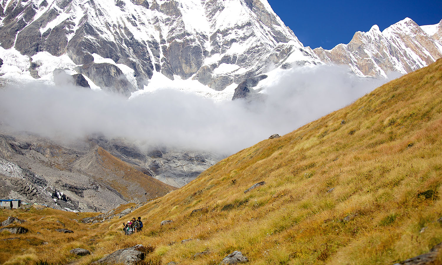
I’m on the adventure of a lifetime: a 12-day trek climbing through the spiritual wilderness of the Himalayas to Annapurna Base Camp. At 4310 metres (13,550 feet), she is the smaller, less famous sister of Mount Everest. While Everest is synonymous with the summiting elite and famed for its record-breaking altitudes and desolate, dramatic vistas, the Annapurna ranges are a utopian wonderland of rice fields, bamboo forests, gushing rivers and quaint villages.
With a group of 10 trekkers, five Sherpas and five porters, I’m embarking on the Maiti Trek, a fundraising expedition with BluSheep Tours. Trekkers raise AU$1000 (about US$750) to participate (on top of the hike fee), with proceeds going to either Maiti Nepal, an NGO fighting against the trafficking and slavery of women and children, or Women Lead, a leadership development group for Nepalese women.
Our journey begins with a 30-minute flight from Kathmandu to Pokhara in a tiny 30-seater aircraft. We file into jeeps and quickly discover it’s every driver for themselves as we hold on for dear life, careening through the city’s streets, dodging potholes, motorcyclists, cows and the occasional herd of goats. We soon leave civilisation behind and the urban landscape recedes into a tangle of leafy trees, mountains smeared with grass and rural vistas infused with the freshest air.
Our Sherpas are Pasang, Kiran, Dawa and Pemba. They are a tight-knit bunch. Pasang is Karma’s right-hand man. The others are young and excited; Pemba is Karma’s son, Dawa his nephew, and Kiran a family friend who lives in their building. Karma tells me on the sly that Pemba begged to come on the trek. “I said yes, but only if he does his homework,” he chuckles.
We set off from the outskirts of the tiny village of Syali Bazar just after midday. We have no idea what we’re in for and our initiation is brutal. Six hours later, slumped in a chair beside the fire, I have a newfound appreciation for life’s creature comforts. A bed has never looked so inviting.
At 5.30am, the village of Ghandruk is suffused with a soft glow but cold air slaps your face. A field of crops leans towards where the sun will rise. Beyond, a mass of snow-capped mountains surrounds our lodge, so close you can see each crevasse and soft curve of snow. This is the backdrop for breakfast. We fuel up on potatoes and freshly baked bread while gazing at the peaks of Annapurna South, Hiunchuli and Machapuchare, known as the Fish Tail for its unique fin-like appearance.
The first drops of rain begin just before noon, quickly turning into a full-on deluge that brings momentary relief from the heat. Karma explains the monsoon has run later than usual and we are hiking in upwards of 35°C. Even the Nepalese, accustomed to the climate, are struggling with this unseasonable warmth. Our porters, usually impossible to catch, scurry only a short distance ahead of us, their eyes screwed up under the weight of their cargo.
The weather also brings out some sinister creepy-crawlies. “There’s a leech on me!” I squeal. Karma, mistaking my enthusiasm for horror, yanks it from my calf, leaving blood to trickle down into my boot. I’m excited about my first authentic encounter with Himalayan wildlife, but it’s good to know Karma has got my back.
During the afternoon of our third day, our wet-weather gear gets a workout. The soft pitter-patter of rain and the gentle crunching of gravel underfoot are the only sounds that break the silence of the bamboo forest. Everything is green – thick dark trees with bright leaves surround us, wet moss clings to boulders lining the path, and a blanket of foliage sprawls overhead. It’s beautiful, and just when I begin to wonder where all the bamboo is, I see a cluster of it – skinny stems all bunched together – then realise it’s everywhere.
I fall back with Pemba. A pensive 16-year-old, he is as quiet as he is agile, his smile a familiar shade of his father’s. Pemba soon comes out of his shell and we talk about everything, from his aspirations and hobbies to Nepalese politics, corruption and the country’s complex history. Occasionally the conversation slows as I concentrate on a mossy step or a slippery rock, but Pemba doesn’t miss a beat. He leaps in front to help me where he can, latching onto my backpack to steady me as we slog through the deluge, eventually edging down a rugged decline towards the tiny village of Bamboo.
Our days are spent scaling jagged stone steps and trudging through slippery mud. We negotiate precarious log crossings over tumbling rivers. We stop to admire waterfalls cascading down mountain faces, and to appreciate precious epiphanies, like realising we’re standing in the depths of a cloud.
In the afternoons we settle into our accommodation. Luxury lodges morph into sparsely furnished teahouses, a lonely bulb clinging to the end of a cord providing the only light. At night we devour noodle soup, vegetable momos (dumplings) and various interpretations of dal bhat (lentil curry). Apart from each other, a deck of Uno cards is our only source of entertainment. Competition becomes fierce and the Sherpas, who usually keep to themselves, sit down with us, playing along with enthusiasm.
As dawn breaks on our sixth day, I clutch a steaming bowl of porridge inside our dormitory-cum-common room. Today is our final ascent and the group is up early in anticipation, teeth chattering against a soundtrack of snoring from our fellow trekkers. My breath puffs out in a cloud, giving the impression I might start breathing fire at any moment. It’s hard to imagine I’d been drowning in a pool of sweat only days earlier.
The air is thin but I’m yet to feel the effects of the altitude. Most of our group has succumbed to the meds (Diamox is the drug of choice), but I’m quietly confident I can make it to Base Camp without it.
“Zoom, zoom!” comes the marching call from the Sherpas. We file into a valley, enjoying another downhill reprieve before the next climb and thrilled to be so close to reaching the climax of the trek. It takes some time to realise that it’s not excitement that has my heart thrashing against my ribcage like a violent criminal attempting a prison break, but altitude. My breath comes in short sharp rasps and I stagger, trying to suck in lungfuls of air. I make it to a plateau and rest, close my eyes and try to calm my heart rate. The oxygen is noticeably lacking up here, my inflated ego expiring with it. For the first time I can empathise with my fellow trekkers.
We break for lunch at Machapuchare Base Camp – the final pit stop before we reach our destination. The sacred Fish Tail is unconquered and off-limits to climbers, who fear being struck down by Lord Shiva, who is said to reside on the summit, or so the legend goes. However, its virgin status has been questioned over the years. The only known attempt was in 1957 by British trekkers Wilfred Noyce and A.D.M Cox, who turned back just 150 metres from the summit at the behest of the King of Nepal himself.
Clouds materialise, swirling above us, consuming the last rays of sunshine. By the time we resume walking, the cloud cover is so dense anyone more than a few steps ahead seems to vaporise in the fog. There’s little sign of life, save for the light whistle of wind through the grass and the sound of water trickling somewhere in the distance.
After what feels like hours, I spot a flimsy wooden sign and the flash of a colourful prayer flag rippling in the wind: “Namaste. Amazing Annapurna Base Camp…” Whoops of glee bounce between us. After thousands of stairs, suffocating heat, torrential rain and overcoming our mental demons we have made it.
Well, we assume we have. We can’t see anything.
Despite the poor visibility, we celebrate somewhat deliriously with steaming cups of tea and coffee flowing hot into our bellies. That night we collapse into bed with the greatest satisfaction, chattering excitedly before fatigue gives way to sleep.
It’s barely light and a crowd has already assembled at the viewing point, rugged up in beanies and thick down jackets. The air buzzes with excitement. What was invisible on our arrival is now emblazoned before us like stills on a giant projector screen – charcoal peaks coated with soft white powder puncture the sky surrounding us. Karma points to each peak, naming them: Annapurna I, Barasikhar, Annapurna South, Hiunchuli, Machapuchare, Gandharva Chuli…
“The sun will rise on Barasikhar,” he says, rubbing his hands together.
There’s a collective inhalation, followed by a silence that sweeps across the hilltop. The sun breaks over Machapuchare and the peak of Barasikhar is illuminated in a soft rose-gold that oozes down the mountain. For a moment I forget that I’m sore, exhausted, freezing and looking every bit like I haven’t showered in three days. I witness the elements align for this one glorious moment, consumed with an overwhelming sense of gratitude for this simple, flawless show of nature.
All too soon it’s time to start our journey back. I’m not ready. There’s something inside me that says I’m home. With one last look, I vow to return one day and we begin our slow and steady descent.
It turns out it’s a lot harder going down than it is up. The descent quickly takes its toll on my knees and my feet feel like compressed balloons set to explode. When we eventually shuffle into the colourful village of Jhinu Danda on our last full day of trekking, hot springs trump the lure of a shower. We sink into the steaming riverside baths, our aching bodies shrieking with pleasure after the previous two days of downhill torture.
“Tea? Coffee? Hot lemon?” I smile at Dawa as he gathers everyone’s morning beverage order, a lump forming in my throat. This is the last day with our Sherpas before we say goodbye. I’ve become used to their familiar presence; through this journey we have become one big family.
Less than 24 hours later I’m back in the bustle of Kathmandu. We meet with the Maiti Nepal and Women LEAD charities, and it’s only now I appreciate the enormity of what we’ve accomplished. We are greeted with a sea of toothy smiles, enthusiastic waves and tender embraces infused with the kind of emotion that sinks deep into your soul. These women and children have experienced horrors darker than we can imagine, yet they exude an aura of hope and courage.
I have overcome mental and physical hurdles to conquer the challenge of a lifetime, but my journey pales into insignificance in this company. These people are the epitome of strength.
I trace the flight of a butterfly that darts through the open canopy of our boat and out over the gleaming Java Sea lagoon. As it disappears my eyes settle on an island of surreal granite boulders that hold their backs to the water.
Fine white sand spills from between the rocks onto a gentle beach where painted wooden vessels nuzzle each other and a handful of people dip their feet. For a moment I feel a pang of loss as we pass by without stopping, but when I widen my gaze a dozen similar configurations of boulders, white sand and coconut palms come into view. It’s as if the beaches are clamouring for visitors but there aren’t nearly enough to go around.
With the help of Rusty, a self-styled tour boat captain and beach shack restaurateur, I’m exploring a chain of uninhabited islands off the coast of Belitung, a modest island between Borneo and Sumatra. In 2009 this beautiful coastline starred in the one of the biggest box office hits in history, but unless you’re a late-night SBS movie buff you’ve probably never seen it. That’s because the film is Laskar Pelangi (Rainbow Troops), a runaway success for the Indonesian film industry that sparked a mild boom in domestic tourism for this otherwise obscure island, once known only for mining. For me, it’s clear that the potential here has barely been tapped.
Rusty drops me off at Burung (Bird) Island, where a picnicking family waves to me through a cloud of lemongrass smoke before I hit the beach. On all sides of the island boulders lie like giant marbles cast by the handful. They tumble down from among the palms and create private patches of sand along the shore. I briefly lament that there’s no surf to break over their haphazard arrangements. But, in a region revered for surfing, this stretch of beautiful, calm water is obviously overlooked by the masses – and that’s no bad thing.
Visitor statistics show that 91 per cent of Australians who visit Indonesia go direct to Bali, and few venture much further. Yet locals proudly inform me there are 17,507 other islands begging to be explored in what is a vast and diverse archipelago stretching across three time zones. It strikes me that if I were to spend a day on each island I’d be in Indonesia until 2060. I could think of worse ways to notch up my seventy-fifth birthday.
The blue streaks that have so far stuck to the horizon suddenly engulf the island in a torrent of well-fed raindrops, which send us packing for Rusty’s boat. After a turtle sighting and a few Bintangs that are even more refreshing than the downpour, we arrive at Tanjung Tinggi, the principal beach featured in Laskar Pelangi and the spot where the mild bulk of domestic tourism lands. A charming strip of low-key restaurant-shacks sits back from the beach under deep, broad-leafed shade; a newly erected plaque proudly proclaims this to be “the film site of Indonesia’s most popular movie”. Teenagers scramble among even more elaborately laid boulders, while young men on esky-saddled mopeds casually hawk es krim (ice cream).
Our van gets bogged in the sandy beach track and somehow I become famous among a group of families visiting from Jakarta. They’ve got the idea I’m a celebrity contestant from the Australian MasterChef series (Indonesia’s highest rating TV show) and are queuing up with their camera phones. I suspect Julietta, a mischievous young lady also on Rusty’s tour, has deliberately spread this playful rumour.
Leaving Tanjung Tinggi, we cruise past many kilometres of undeveloped beachfront before arriving at the only resort on the coast. Despite its comfortable villas, the resort somehow manages to pull off both unfinished and rundown at the same time. One of the island’s innumerable boulders has been concreted into a seemingly abandoned water feature that adorns the entrance. I can’t help thinking it looks unflatteringly like a giant gonad. With a touch more poetry, Julietta suggests that it’s more of a Buddha in waiting, a masterpiece yet to be carved. It’s a fitting metaphor for tourism on Belitung.
An hour’s ride away I discover the world’s most delicious chilli crab at Mutiara, a low-key wooden slat restaurant in Tanjung Pandan, Belitung’s capital. For dessert I return to the resort for Indonesian chocolate, banana and cheese fritters. The illogical mix somehow works for me, but I’m pretty sure it’s the Bintang talking. I manage to haul my bursting stomach into bed as the sound of a distant call to prayer mingles with a gentle shore break from the beach. A gurgling moped passes by with a young girl singing on the back and I’m lulled to sleep.
In the morning I breakfast on rice pudding, chilli sambal and peanuts, before my driver takes a shortcut to the airport through an immense palm oil plantation.
Staring down the flickering rows of converging monoculture, it’s clear that tourism is far from the mainstay of the local economy. My plane dodges a pack of dogs on the tarmac before taking off to reveal the unmistakable effect that tin mining (Belitung’s former primary industry) has also had on the island. Pools of deep emerald and turquoise choke a number of waterways amid eroded tailings, thick carpet mosaics of palm plantations and remnant rainforest.
When I arrive on neighbouring Bangka Island it’s clear that this place is in the midst of a mining boom of its own. Santana electrifies the stereo as we weave through traffic and my guide, Toto, explains: “We have no beggars on Bangka, not even street musicians; you can earn four to seven times as much in mining.”
But Toto doesn’t see a long-term future in it for Bangka and is worried about the effect illegal mining has had on parts of the island’s natural environment and fisheries. He is hoping that tourism can provide a more sustainable future for his home and has given up lucrative opportunities in mining to promote Bangka as a destination.
Our van pulls up beside an improvised sign proclaiming “hati hati” (be careful), before easing past a team of road workers near a mine site. Leaving this eyesore behind, we roll on to a market garden run by some of the island’s Chinese minority and lunching on baba guling (suckling pig) at Toto’s 84-year-old grandmother-in-law’s house.
It emerges that Toto’s marriage was both mixed faith (Islamic and Christian) and interracial (Chinese and Malay), and that he later decided to convert from Islam to Christianity, although not to the same church as his wife. His story is extraordinary, but somehow seems to sum up both Indonesia’s diversity and its religious tolerance. Later, I visit the local mosque, before the heat and hours of driving lure me back to the beach.
After exploring a selection of palm fringes and white sand that almost rival Belitung for their beauty, I check myself in for a Javanese massage. I meet Maya, a smiling 24-year-old masseuse from Jakarta with braces, yellow eye contacts and a frame somehow skinny and curvy at the same time. She teaches me how to say aku cinta kamu (I love you) in Bahasa Indonesian and leaves me with a bruise in my calf. Hati hati.
In Sungailiat, Bangka’s second-largest city, I visit a school and an impressive food market before checking out the appropriately titled Eat and Eat evening street food court. An incomprehensible talent show is televised on a giant projector screen while dangdut (the Indonesian take on booty-shaking Indian bhangra music) blasts from the bustling food stands with similar force to the smoke and steam.
Toto recommends the beef rib, and it’s on par with the chilli crab in Belitung – world class. I’m less enamoured with the “genuine bird’s nest–flavoured drink”. Toto explains that it’s made from the nests that swallows build with their own dried saliva. I’m drinking saliva. Luckily, a broad selection of fresh fruit juices and traditional chocolate and cheese martabaks (Indonesian pancakes) quickly come to the rescue of my palate. The Bintang is definitely still talking.
On my last night, Toto explains before departing that there is only one nightclub on Bangka. Unfortunately it’s on the other side of the island, so instead I find my way to Parai Tenggiri Resort’s open-air karaoke bar. Two Javanese cowgirls on the microphone are violating Consuelo Velázquez’s ‘Bésame Mucho’, while a keyboard player flinches along admirably with his synth mode set to Spanish guitar. I offer my finest attempt at ‘Yesterday’ by the Beatles, before requesting salsa and coaxing the cowgirls away from the microphone to teach them some Cuban steps. It earns me an invitation to the table of a Chinese family who ply me with wine and encourage me to salsa with their daughter. I’m rewarded for acquiescing with an armful of fresh dragon fruit from the family farm.
Before going to bed, I catch the silhouette of a 30-metre sculpted eagle with a salmon in one claw. It stares down at a giant toad that will double as a fountain, one day spewing water from its mouth into a swimming pool, which is, as yet, just a pit of excavated earth. They’re without doubt the gaudiest and most bizarre constructions I’ve ever seen (think Disneyland meets a ‘big’ attraction from the side of a lonely Australian highway), and they’re the ornamental centrepiece of Bangka Island’s newest resort. I wonder for a moment what was so wrong with the view of the resort’s beach cove that warranted obstructing it with this un-attraction. Then I cast my mind back to the kilometres of undeveloped beachfront on Belitung. What will be their fate? Will an army of giant technicoloured animals migrate across the seafloor like Indonesian Godzillas? It sinks in how lucky I was to experience the Buddha uncarved. In many ways it’s already a masterpiece. I hope they’re subtle with the chisels, or whatever they fashion on top.
 (
(