After Dark in Dublin

Traditional Irish pubs sprout in almost every city in the world, and it’s 
no wonder – the Irish are a gas. In Dublin you could spend weeks drinking pints of Gat in bars once favoured by literary gods, and you’d be an eejit to ignore them. But behind the city’s charming facades and colourful Georgian-era doors there’s also a burgeoning world of cuisine, craft beer and creativity all closely tied to history but forging a decidedly modern, most definitely cool Dublin.

4pm
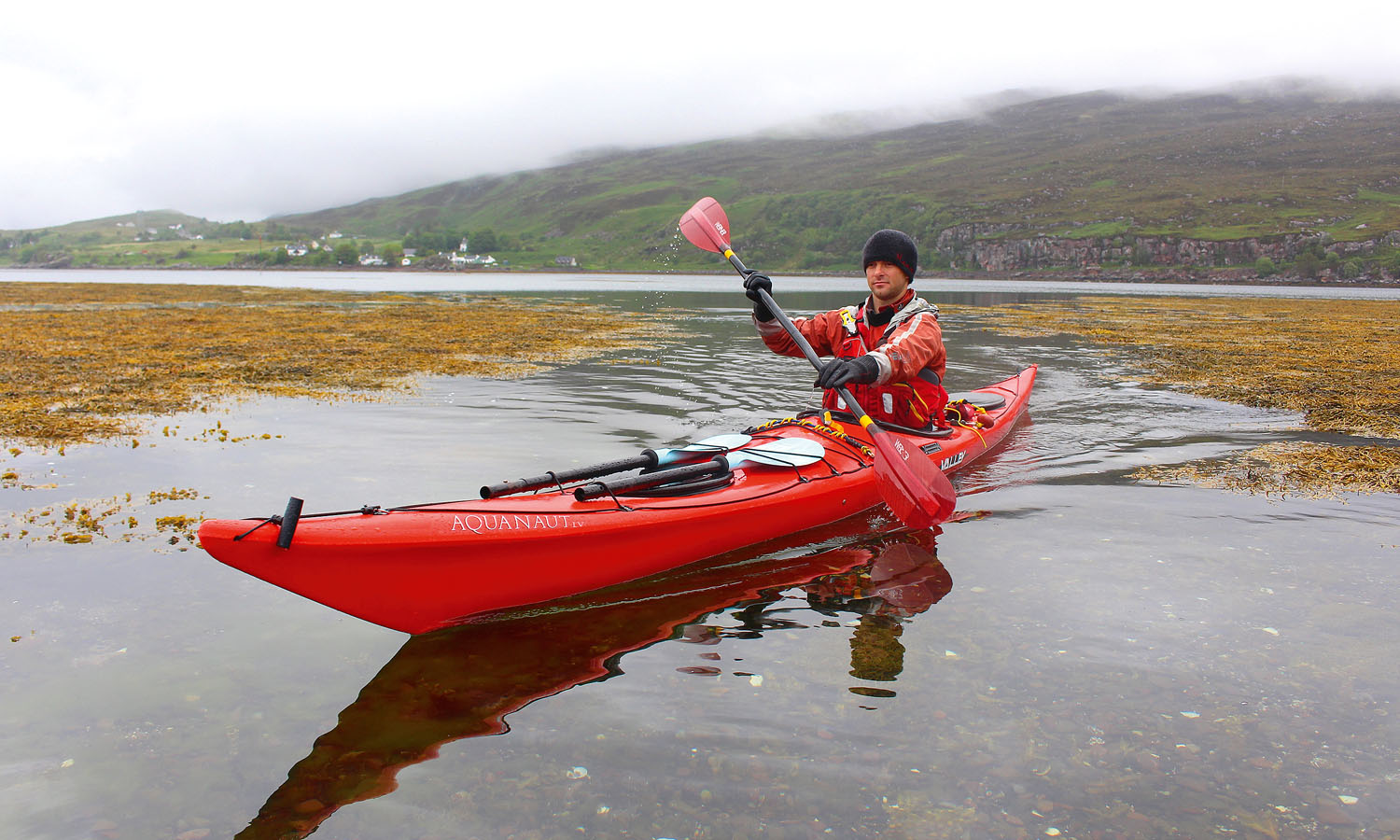
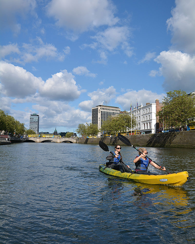
Make for the banks of the River Liffey, the waterway slicing Dublin in two and providing neutral territory over which the city’s ‘dodgy’ Northsiders and ‘spoilt’ Southsiders hurl jibes at one another. Of course, most Dubliners swear they’re above such ribbing, but they’ll still throw a dig or two for a laugh. Before you declare allegiance to one particular side, meet up with the crew from City Kayaking, pull on a pair of oversized plastic pants, slide into a vessel and drench your local guide with questions as you glide between the two. On warm summer afternoons – think around 22°C – you might even spot a few Dubs, as the locals are called, plunging from bridges or just bobbing along with the current.
City Kayaking
Jeanie Johnston Tall Ship
Custom House Quay
citykayaking.com

6pm
Despite the plastic protection, by the time 
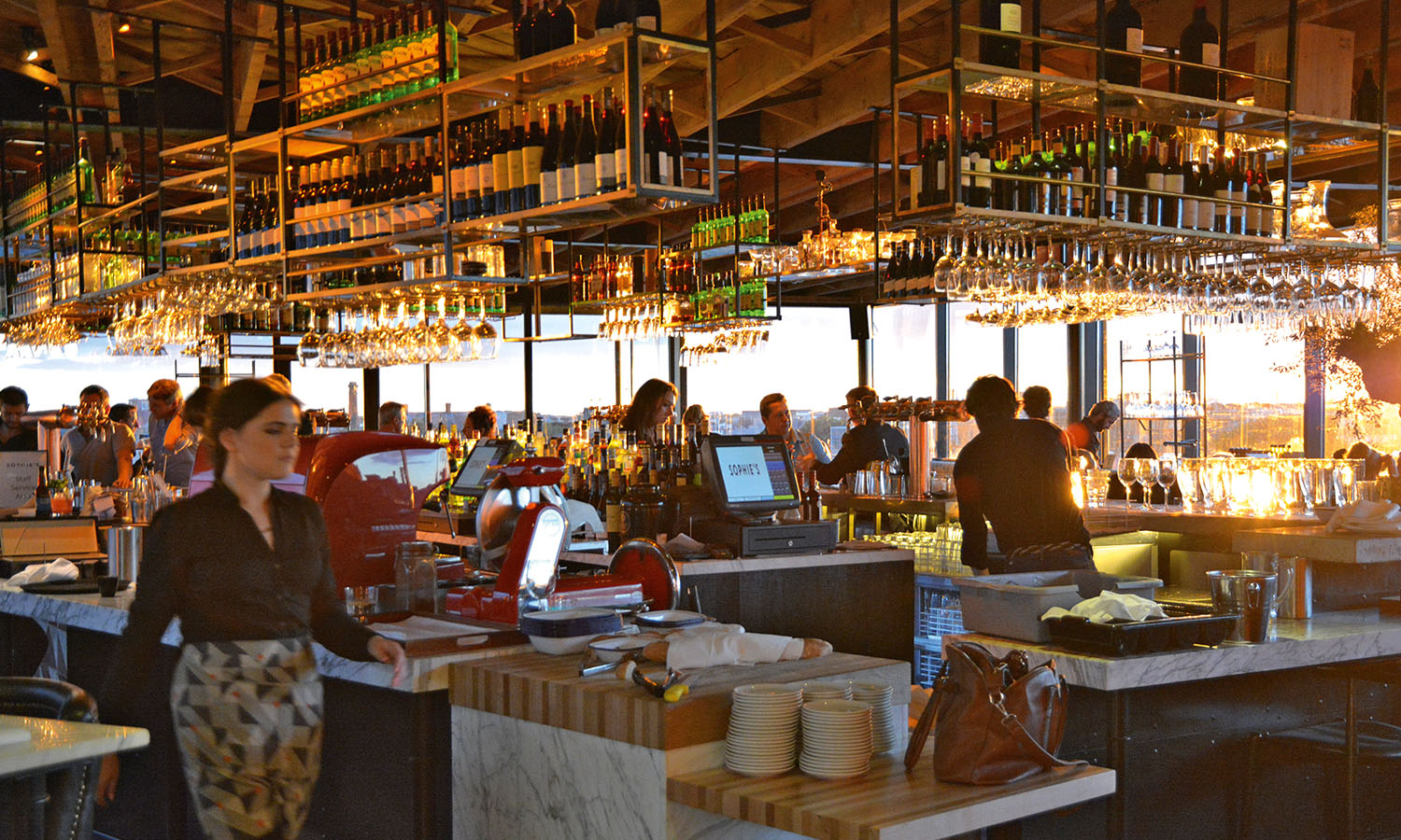
you clamber out of your kayak your lower half will be soaked. Even if you did remember a change of clothes (bet you forgot your undies) you won’t want to carry your sodden stuff around all night. Taxi south to the Dean Hotel, your evening digs, dump your soils in your room (resisting the lure of the well-stocked Smeg minibar) and head for the rooftop. After a quick ride on the indoor swings, nip into Sophie’s restaurant for a drink. The space is stylish – think warm metal, marble and gnarly old olive trees – but it’s the rare panoramic view over the low-rise city that’s most arresting. Lock eyes on St Patrick’s Cathedral before heading down the hall to the Rooftop Bar to polish off another tipple.
The Dean Hotel
33 Harcourt Street
deanhoteldublin.ie

7pm
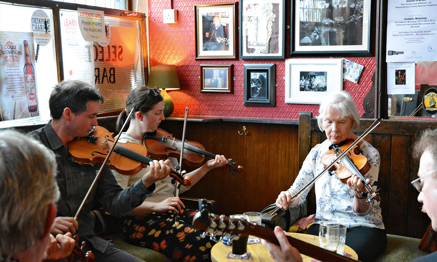
Music courses through the veins of the Irish, and a night out isn’t complete without swaying to traditional tunes with your heart on your sleeve and a Guinness in your hand. Avoid the overcooked stuff in the Temple Bar area, aka Dublin’s tourist trap, and seek out the Cobblestone, a classic Irish pub north of the river. This is where the locals go, as well as a smattering of tourists who have caught wind of the craic (fun) that flows here. Each night the pub invites a couple of musicians – fiddlers, mandolin or bodhrán (hand-held drum) players, depending on the night – to share some melodies, and the numbers swell when locals turn up to jam too. Palm over €4.50 for a well-poured pint of the good stuff and settle in beneath the portraits of performers lining the walls.
Cobblestone
77 King Street North, Smithfield
cobblestonepub.ie

8pm
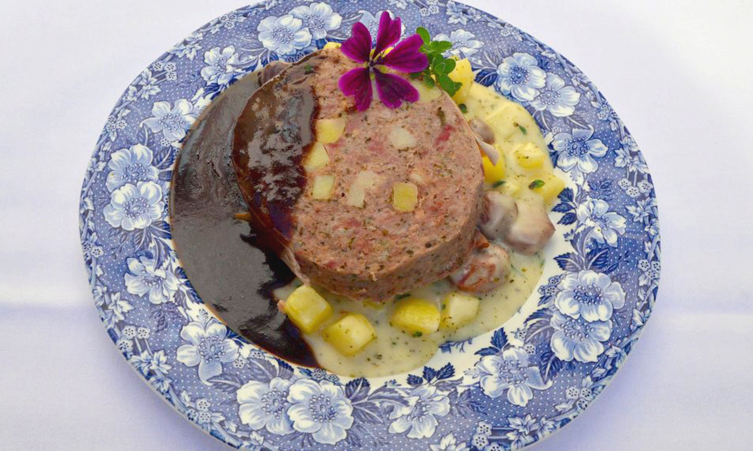
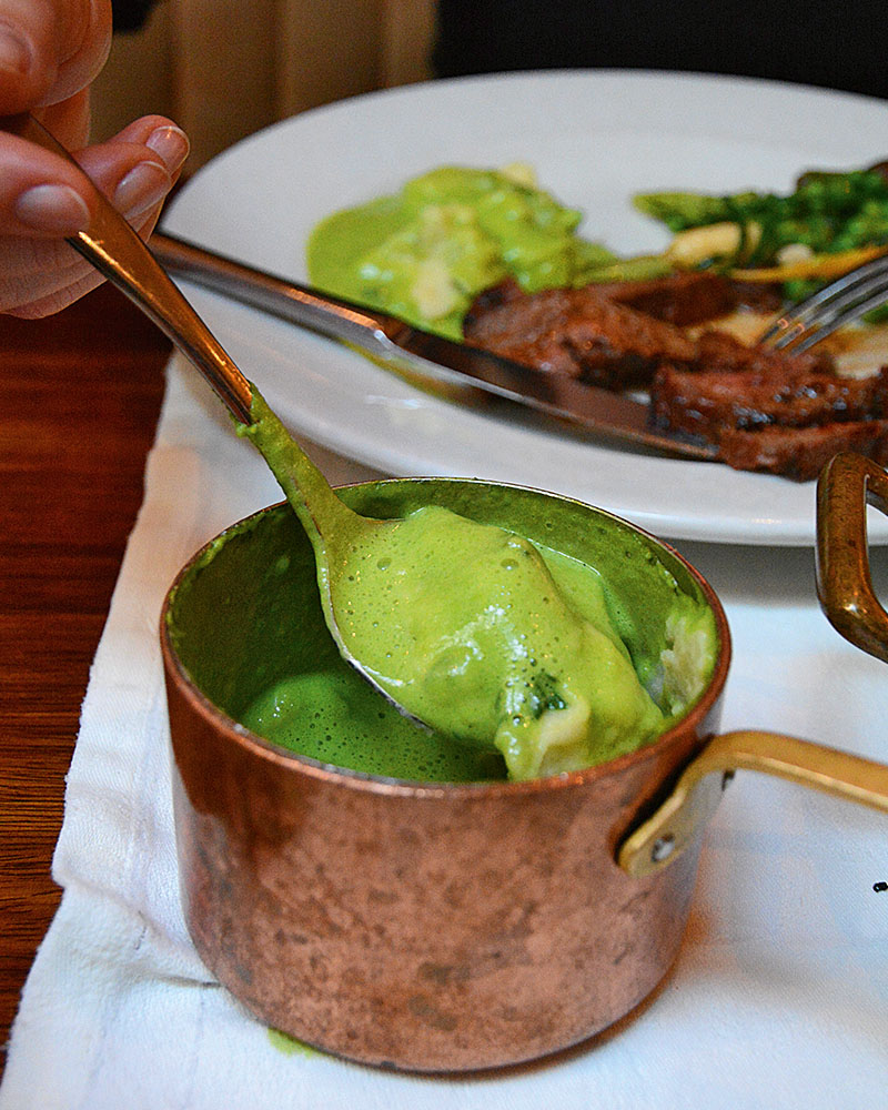
A glass of Guinness may feel like a meal, but if you want to survive the evening you’ll need more than a liquid dinner. Despite Ireland’s proximity to England, its cuisine is worlds apart from the infamous stodge once served by its neighbour. Fresh seafood, tender lamb and artisanal cheeses grace the menus and, for a city of just half a million people, Dublin claims an impressive array of gastropubs and restaurants. For fresh local produce, book a table at Fade Street Social by Irish celebrity chef Dylan McGrath and salivate over a selection of wood-fired flatbreads, rabbit and trout, or that day’s choice cuts of chateaubriand, tomahawk steak and Denver roll. Add a side of micro veggies and feast on a modern take on the traditional Irish dish colcannon – this incarnation features vivid-green kale foam and creamy mash scooped from a rustic copper pot.
Fade Street Social Restaurant
4–6 Fade Street
fadestreetsocial.com

9.30pm
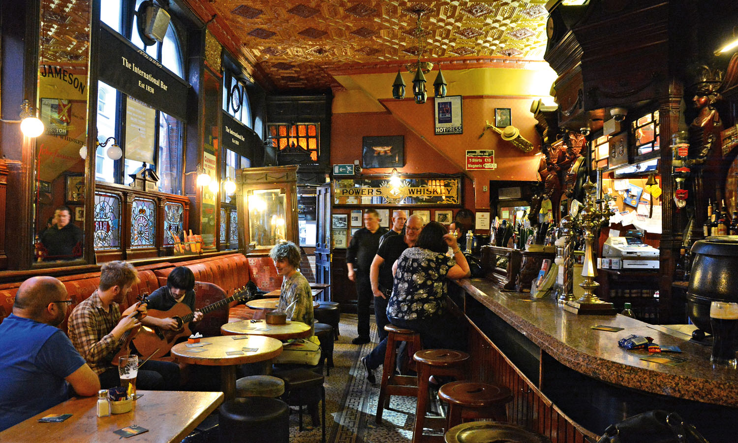
The Irish are famed for their wit and if you haven’t cracked up a half-dozen times since your night began then something must have gone ‘arseways’. For real belly laughs look no further than the long-running comedy club at the International Bar, less than five minutes’ walk from Fade Street. Gander at the traditional pub’s pink granite bar set beneath hand-carved mahogany panelling on the ground floor then scurry upstairs to the dimly lit den serving comedy seven nights a week. Expect gags from up-and-coming acts and, if you’re lucky, a big name testing new tricks.
The International Bar
23 Wicklow Street
international-bar.com

11pm
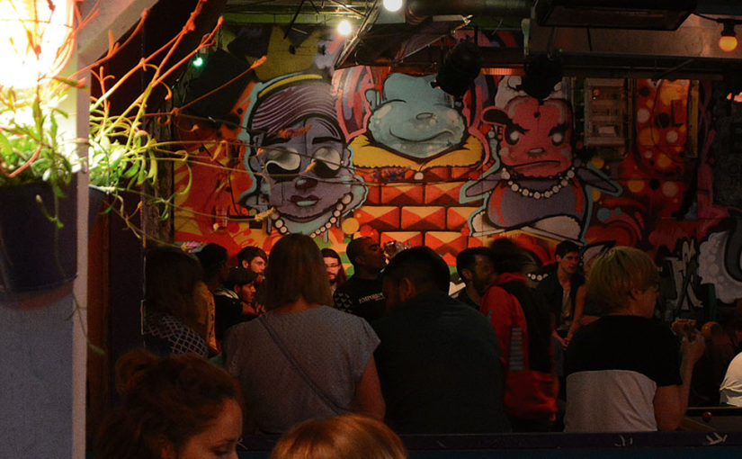
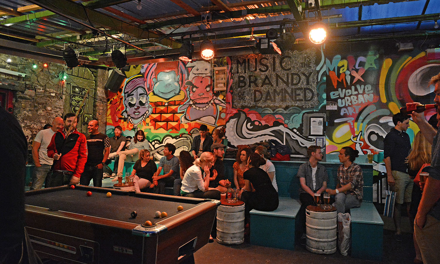
Take a break and relish those laughter-induced endorphins at the Bernard Shaw, further south in the Camden Quarter. It may be named for the famous playwright and author, but this eclectic venue is more a multifaceted drinking hole than a thought-provoking literary den. During the day it plays the part of an artsy cafe, on some weekends it’s a flea market and at night it’s a top place to party. Head to a back room where you’ll find a DJ spinning tracks for those on the dance floor or spill into the beer garden adorned with street art where the Big Blue Bus, a brightly painted, pizza-serving double decker, takes centre stage. If you’re lucky nab a seat up top or lounge on the bleachers for a spot of people watching. If you still have energy to burn grab a pool cue and challenge some opponents.
The Bernard Shaw
11–12 South Richmond Street
facebook.com/thebernardshaw

12am
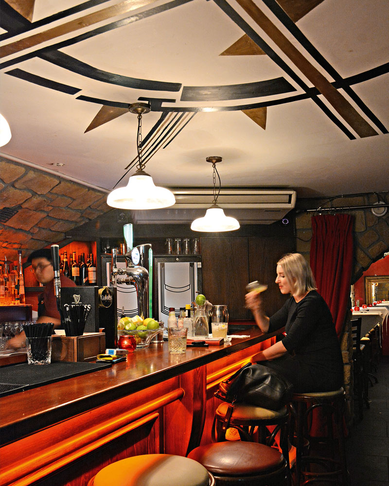
Now that you’ve dabbled in the city’s pub scene, a hidden underground speakeasy awaits. Getting inside the Blind Pig requires pre-planning but it’s worth the effort. You’ll need to reserve a space online in advance and await instructions and secret door codes to drop into your inbox. Clues will take you past a huge metal gate, down an alley and through a sealed entrance before you descend into a cellar. Once inside the cosy vault, swill a gingerbread daiquiri or, if a martini tickles your fancy, be sure to try one made with ShortCross gin, distilled in Northern Ireland. The head bartender mixes it good enough to floor James Bond so don’t go overboard – you still need to find your way back out.
The Blind Pig
theblindpig.ie

1am
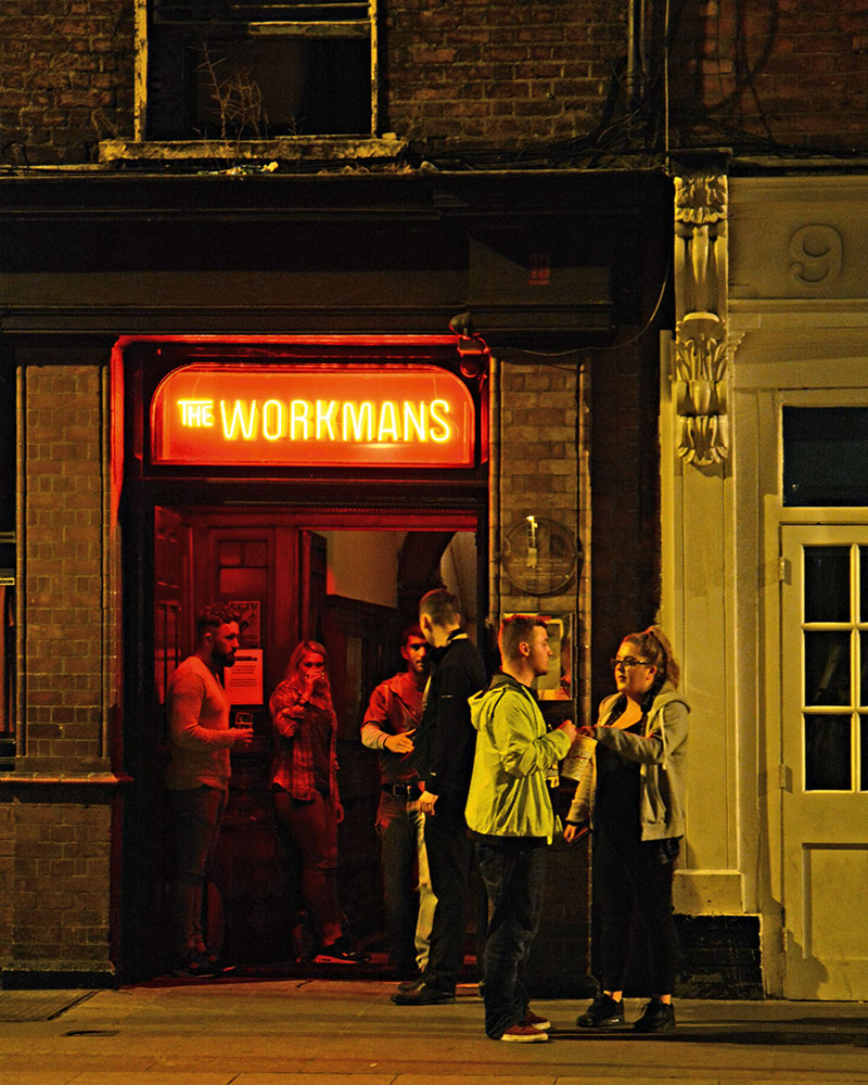
If you’re not too plastered, totter back to the banks of the River Liffey and find the Workman’s Club. Once you’ve passed the bouncer it feels a whole lot like you’ve rocked up at a house party – albeit one with a stage. Performers smash out sets to punters packed to the rafters earlier in the evening, and DJs spin rockabilly, hip-hop and house until the wee hours. Old staircases connect a jumble of rooms and if you need to come up for air the revelry keeps on going up on the rooftop terrace.
The Workman’s Club
10 Wellington Quay
theworkmansclub.com

3am
Time to soak up some of the evening’s booze with a serve of that late-night snack loved the whole world over – the humble kebab. Stumble to Temple Bar to join the throng at Zaytoon. At opening time its spits are so big you’d struggle to wrap your arms around them and, after a busy night, hungry party monsters will have devoured up to 140 kilograms of meat. Hover near the kitchen while you wait for your doner and watch the cook pummel lumps of dough into pancakes, toss them into a searing oven, then pluck them out less than a minute later when they’re fragrant and ready to eat. Tuck in and scare away tomorrow’s looming hangover, or the fear as it’s known here.
Zaytoon
14/15 Parliament Street, Temple Bar
zaytoon.ie

Germany’s wine bounty

There’s something about wine routes: the sight of tethered vineyards, the undulating countryside and the obligatory mild climate, since vines demand a healthy dose of sunshine. There’s also that feeling of discovery. I get it when I’m bowled over by a fine vintage that makes the day’s drive worthwhile. Plus, of course, where there’s excellent wine, good food generally follows.

What I didn’t know is that the road I’m on this time, the Deutsche Weinstrasse, was the first wine route in the world. Running for 85 kilometres in the German region of Pfalz (Palatinate), it was inaugurated in October 1935 to help the local wine growers boost sales. What is more surprising is that it’s still refreshingly idyllic, meandering by sloping vineyards and winding through well-kept villages with timber-veined houses and geranium balcony blooms.

This has been prime wine country for centuries. Near the top of the Weinstrasse lies Ungstein, where a Roman winery has been excavated complete with grape-treading troughs. They are so intact experts have determined the Romans were cultivating riesling, pinot and gewürztraminer – the same varieties that are planted in the region today.

I have to fight constantly with my GPS that directs me away from village centres to the nearby highway, until I switch it off and simply follow the road signs of black grapes on a yellow background indicating the Weinstrasse. I’m aiming for the small village of Weyher in the shadow of the massive Pfalz forest, where the restaurant Zum Kronprinz has stood as long as folk memory serves. Rupprecht, the last Crown Prince of Bavaria, regularly stayed over after a forest hunt and endowed it with its name.

“My family has been running the restaurant for generations,” says Simon, the chef. Rotund, jovial and chatty, he is the embodiment of country cooks the world over. “Back in the 1970s, the restaurant was famous for its bear stew. My grandfather used to import bears from Russia and slaughter them for food.”

He shrugs his shoulders and winks. “Until animal rights campaigners stopped the trade. But it’s all ancient history. Nowadays we cook game seasonally. Hunters bring us deer, wild boar or game birds from the forest. Come here in May to taste maibock, one-year old buck, which we shoot in the spring.”

Does the nearby forest dominate local cuisine?

“Of course, we all like to forage every now and again. The older folk especially treat the forest like their back garden; they know exactly where to find mushrooms and ripe berries. We also plant carrots, potatoes and other root vegetables. On top of that we have many fig trees and sweet chestnuts, because of the temperate climate.”

Simon shows me a jar. “This is homemade fig mustard,” he says. “Goes very well with burgers. To make some, you just add fig jam to a grain mustard and there you have it.”

Apart from making good use of the forest’s bounty, Pfalz’s farmers are big on pig rearing – like the rest of Germany – and people here tend to utilise every part of the animal. And I mean every part.

Simon leads me to the kitchen where the local speciality, saumagen, has been cooking for two hours and is ready for sampling. Notorious in Germany for being the favourite dish of Chancellor Kohl, it translates as “sow’s stomach”. I glance at it more in trepidation than eagerness. Many world leaders, including Thatcher, Clinton, Reagan and Mitterrand, shared my dread when they visited Kohl, knowing what would be served as dinner’s main course.

The origins of saumagen are lost in the mists of time. Some say it was poor people’s fodder, made using leftover scraps of meat and veg stuffed in a pig’s stomach and boiled. Others claim butchers stored their best meat there. During the frequent invasions, soldiers would loot the shops bare, but wouldn’t touch the stuffed stomachs hanging on the walls. Looking at the inflated sack bubbling slowly in the pot in front of me, I know I wouldn’t either.

Simon takes out the saumagen, cuts it in half and carves a generous portion for me. He splashes a red wine gravy on top and adds a few spoonfuls of creamed potatoes on the side. I check the meat slice carefully; it’s convincingly disguised as a round meatloaf.

The moment of truth has arrived.

My teeth cut through the soft flesh and a sublime sense of meatiness, tempered by marjoram, invades my palate. For a minute I truly believe I’m in carnivore heaven. It’s as if all the porcine flavours – the tender sweetness of a lean pork chop, the salty, smoky taste of a bacon rasher, the melt-in-the-mouth texture of a pulled shoulder – have been concentrated into a single mouthful. I finish my plate in record time.

Saumagen

Serves 6

INGREDIENTS
750g thick-cut bacon
750g lean pork belly, rind removed
750g potatoes, boiled, drained
1kg pork mince
3 small bread rolls, soaked, drained
4 large eggs
1 tsp marjoram
1 pinch nutmeg
1 small pork stomach (order from butcher)*
10 bay leaves
1 tbs juniper berries
1 tbs marjoram, extra
1 tbs peppercorns

METHOD
Dice bacon, pork belly and potatoes into 1cm cubes. Add mince, bread, eggs, marjoram and nutmeg, then season and mix well.

Rinse the stomach thoroughly and pat dry. Close two of the stomach’s three openings with kitchen twine, then fill loosely with the pork mixture. Overfilling will cause it to burst during cooking. Tie off the final opening.

Bring a large pot of salted water to the boil, then reduce heat to a simmer. Add the stomach and cook for three hours. Add the bay leaves, juniper berries, extra marjoram and peppercorns to the pot and continue to cook for another 30 minutes. It’s important the saumagen doesn’t boil at any time during the cooking process. It is cooked when a fork pierces the stomach and it falls cleanly back into the pot.

To serve, cut into slices, plate up with creamy potatoes on the side, and top with gravy.

* If unavailable, use sausage skins or cook the filling as a meatloaf.

Bring Out Your Dead

The halcyon days of my youth are locked in a trunk in my memory’s attic, a little like the journals filled with old family photographs stashed at home. As I get older I find myself flipping through those journals more and more, especially as work takes me further away from family for extended periods of time.

I clung to my youth for 30 years, but when cold-hearted Time suddenly and without warning took away my Aunt Linda in the spring, I was faced with the grim realities of adulthood: we grow up, we grow old and we die. My aunt and I were close. She was one of the most supportive and encouraging people I’ve ever known, and liked to crow to her friends that she kick-started my career when, on my seventeenth birthday, she gave me my first film camera.

The last time Linda and I spoke was shortly after Halloween. I was on assignment in South America, deep in the heart of a place wildly foreign to the rest of my family, but my aunt knew her way around a map. “Are you in one of those countries that paint the skulls?” she asked. I told her the big Day of the Dead festivals were held in Mexico and Guatemala. “I’ve heard of the Día de los Muertos,” she said. “Guatemala is the one with the Festival of Giant Kites, which locals use to communicate with the dead. Can you imagine what they’re saying?” At the time I couldn’t, and it took some time to muster the courage to visit Guatemala with my own farewell message.

On 31 October, Antigua’s cobbled streets heave in festive anticipation. Ladies in variegated outfits dress their tostadas in purple cabbage skirts, the canary-coloured church of La Merced proudly sports a garland of freshly cut flowers, while young folks dressed like Miley Cyrus cram into tuk-tuks with fireworks and bottles of Ron Zacapa under their arms. Antigua’s elderly Baroque bones love an old-fashioned shake and rattle, but I’ve come for something more subdued. I cross Plaza Union and pause for a moment to embrace the beauty of the ruins of the Santa Clara Convent and buy a small paper kite from a street vendor, before pushing back through time across the great wooden threshold at Casa Palopo Antigua, an immaculately restored colonial home that only betrays the calendar by displaying dates on the bottles of rum in the bar. I’ve accepted an invitation to a dinner party hosted by chef Mirciny Moliviatis that promises to explore themes of family and tradition.

Chef Moliviatis’s molecular gastronomic genius brings to life the capricious cuisine of her childhood. Her deconstructed sopa de frijol (black bean soup) and whimsical popcorn pork rinds are playful nods to her grandmother’s home cooking, and remind me of the times I used to sneak into the kitchen during the holidays to watch my mum, aunt and grandmother spin their Austrian magic. Adventure comes to the table disguised as fiambre, a traditional Guatemalan salad made using more than 50 ingredients and served as a precursor to the Day of the Dead festivities. I consume the blood sausage and olives with abandon, but high step over the brussels sprouts. Dinner guests go around the long wooden table telling stories of their favourite childhood meal, each of us spending a few moments raising a glass to someone we’ve lost.

Every 1 November, Sumpango, an otherwise sleepy village in the Sacatepéquez district, welcomes more than 10,000 revellers keen on communicating with the dead during the Feria del Barriletes Gigantes, or the Festival of Giant Kite. I’ve made the short trip from Antigua, but as I stare out over the dusty soccer pitch crowded with giant kites, I feel as though my little medium, less than a metre wide, may be an inadequate messenger. Some of the intricately designed tissue-paper giants, adorned with Mayan cosmological icons, stand 20 metres tall and require the strength of a dozen people to heft their creaky bamboo skeletons into the air, where sheer force of spirit keeps them aloft. When these giants do fly, they carry the tidings of the entire town with them. I’m not quite ready to fly my kite, so I wander. I visit half a dozen food stalls, sip on chicha de hora (fermented corn beer), and dress my kite with paper-thin accents before descending into the busy graveyard, where children flit among the headstones in an effort to elevate their own tiny kites.

Jubilation hangs in the air, which is not what I would have expected from a graveyard packed with mourners. This feels like one of the happiest places I’ve ever been, a strange departure from the cemeteries I’ve visited back home. Tombstones and burial mounds have been decorated with fresh flowers and paper ornaments, while entire families picnic in the spaces between. I unfurl my kite and look skyward, but trip over a fresh mound and land on my backside in front of an elderly woman hanging a garland from a wooden cross. I’m terribly embarrassed, but she waves my worries away, takes me by the hand, and tells me of how she’s come to visit her husband on their first year apart. She speaks to him of what he’s missed – the wedding of their youngest son – and the year ahead, and tells me that this isn’t the time or place to mourn. Día de los Muertos is about reconnecting and staying in touch. She tells me to keep that in mind when I finally fly my kite. I thank her for enriching the most moving festival experience of my life.

I’ve drifted further afield in my search for the perfect fly zone, and landed on a volcanic ridge at Lago de Atitlán, a mammoth crater lake where a trio of towering volcanic sentries keep watch over a dozen picturesque Mayan villages. Día de los Muertos is a big deal at Atitlán, and the aftermath is evident – the streets of Panajachel, the main town, are quiet, but bits of tissue paper cling to updrafts overhead. I roll through the village of Santiago, where locals hold fast to ancient Mayan and Tzutujil traditions, the most fascinating of which is the cult of Maximón, a venerated folk saint cared for by the religious brotherhood of the Cofradía. Ages ago, the spry Maximón visited Santiago and bedded all the village wives (at the same time). When the Cofradía returned from the fields they punished Maximón by chopping off his arms and legs, then flipped the script and decided to honour him as an icon. I slip into Maximón’s shrine in time to witness the Cofradía tip the stunted effigy back for a sip of rum, which he chases with a cigarette. I offer Maximón a few quetzales before I leave, bent on dipping my toes in the cleansing waters of the lake. My guide regales me with tales of Atitlán’s guardian serpent and the ruined city of Sambaj, the largest of Atitlán’s archaeological sites, which sits more than 20 metres below the surface. The ruins are more than 2500 years old, yet still people carry the memory of, and communicate with, the departed. I finally feel like I’ve found a place where I’m comfortable bringing up the dead.

I hike some 150 stone steps from the shore to Casa Palopo Atitlán, built into the hills near the village of Santa Catarina. Palopo, with its rustic elegance and charming decor – artist Fernando Botero has his figurative hands all over the walls – is the sort of place my aunt would have wanted to stay forever. I picture her telling me to take a photo of the sweeping panorama while she helps the bartender craft the world’s strongest Irish coffee, before raising her glass to a wild sunset caught on the lips of the volcanic trio. I use my little instant camera to snap a picture of the lake, and fix the print to the wing of my kite. With night falling, I toss the kite into the air and let the wind take hold, hardly slowing the line as it slips through my fingers. Before long the kite is out of sight, carrying what I hope is the first of many messages to a place I’m not quite ready to visit, and a promise to my aunt that she’ll receive a postcard from every stop I make on the road.

Sailing Tonga’s Vava’u Islands

“Hold your breath as long as you can!” yells Nati. “Just don’t panic. You’ll make it. It is only dark for about five seconds, but don’t start coming up until you see some light. Trust me.”

I don’t have much choice. Staring through the crystal clear water, it looks as though there’s a wide-open mouth about five metres below the surface. Once into the black I won’t have enough air to return. I remind myself I am in the Friendly Isles, as Captain Cook called them, and trust Nati enough to take as deep a breath as possible and follow as he disappears into the abyss.

It’s the longest five seconds of my life, but sure enough, up above, I see Nati treading water in a pool of green light. My lungs are almost empty as I kick towards him, somewhat regretting my decision to carry a camera. I surface in an eerie emerald cave half expecting the Wizard of Oz’s evil twin to be hanging from one of the many stalactites projecting from the roof. It is a bizarre feeling as the tide rises, my ears pop with the changing pressure and the light changes as the sunshine refracts through the underwater entrance.

“Welcome to Mariners Cave,” says Nati, his broad smile lighting the cave even more.

One of the many secrets of Tonga’s Vava‘u island group, Mariners Cave is no easy find. We’d spent a morning here a few days earlier drifting along the rocky coast of Nuapapu Island on our chartered catamaran searching the water for a lighter shade of blue that signals the underwater opening. Our exploration was fruitless and we gave up, promising to return with some local knowledge.

Vava‘u is a cluster of 61 picture-perfect islands of various sizes minding their own business in the middle of the vast Pacific Ocean. Known among the yachting fraternity for excellent anchorages and as a pit stop during a Pacific crossing, Vava‘u’s beauty has been a long-held secret. On his third voyage to Tonga in 1777, Captain James Cook was told by the powerful chief Finau there was no suitable harbour, and instead sailed south to Tongatapu. Apparently, the chief was well aware of Cook’s influence, and Vava‘u and all her beauty were to be kept for the Tongans. The yachties we meet on our week-long charter seem similarly inclined.

The perfect combination of extraordinary visibility and an abundance of birthing humpback whales has meant this secret was always going to get out, though. Every year between June and September travellers arrive to swim with these majestic giants of the ocean. We’ve chosen to visit in October when the tourists are long gone, the resort owners are winding down for the off-season and just the odd lazy whale is yet to start its migration south to the feeding waters of the Antarctic.

Landing in Vava‘u’s capital Neiafu is like stepping back in time. There are no hotel chains or cookie-cutter resorts here. Dirt roads roll over green jungle hills linking the odd school with a number of churches. It looks like a set from a James A. Michener film, even more so as the road winds down to the aptly named Port of Refuge. It’s here we’re introduced to our accommodation and transport for the week – a luxury 40-foot catamaran stocked with everything needed for a perfect escape. We sail out the same day, weaving between the anchored yachts flying flags from all corners of the globe. The occasional salty sea dog waves with relief as we navigate safely past. Our chart is scribbled with tips passed on by the team at Sunsail and a couple of yachties drinking 
at the Mango Cafe.

As the port disappears behind us, we seem to have the islands to ourselves. Local children stop their game of beach rugby to wave as we pass by, and within an hour we have dropped anchor off Mala Island in water so blue it doesn’t seem real. The sun sets on our first night and we are rocked to sleep by a gentle swell and soothed by the ocean breezes.

The following days are spent catching the wind to deserted islands framed with palm trees shading white sand beaches. We snorkel through bright coral gardens in water so clear we spot stingrays and reef sharks darting about in the distance. We pack picnic lunches and laze in the shade. The only stress comes as we watch our yacht drift away one afternoon after losing its anchorage as the tide rose. Thankfully the lack of crowds means we have plenty of time to tender out and take control.

We meet a reclusive Australian on Hunga Island living in a rundown resort he plans to restore “when the time is right”. He hasn’t quite arranged his permits properly, but tells us how much happier he is since he left the rat race of a corporate job in Singapore. “It was killing me,” he says. “Out here I feel alive.” He tells us of Swallows Cave and laughs at our inability to find Mariners. “Don’t get too down on yourselves. Some of the locals still struggle to find it. It’s not like there’s a sign. Whatever you do though, get to Swallows as the sun starts to set. Trust me.”

Thankfully Swallows Cave is much easier to find. A 10-metre-high entrance at the point of Kapa Island allows for a leisurely swim into the cave. The late afternoon sun lights the interior and, above us, swallows dart about maniacally. But it is below the water that is most amazing. Thousands and thousands of silver fish school together in three-metre-wide bait balls. The light glints off them as they swirl together in the deep blue water. We spend an hour diving through the parting schools until the sunlight starts to fade and it’s time to find another island for the night.

It doesn’t take long on a yacht charter to fall into a leisurely routine. The days begin relatively early with a plunge over the edge to wash away the effects of too many Ikale Lagers the previous evening. Over breakfast we inspect charts, read up on which islands to explore and choose a few options for that evening. If the wind is right we pull up the sails and make our way. It is impossible to go wrong, as each anchorage is more beautiful than the last.

We join a local family one evening for a Tongan feast. Peter, the patriarch, welcomes us into his home. The Tongans are shy but incredibly friendly, and Peter’s family puts on a delicious spread. His sons sing traditional songs as a huge hog and several chickens wander along the beach behind us. I ask Peter what he does for a living and he smiles widely and says, “This! We love to invite yachties for Tongan feasts.”

“How often?” I ask.

“If we’re lucky maybe once a week.”

It doesn’t seem like enough to raise a family, but Peter explains they want for nothing in Vava‘u. They grow their own vegetables and raise their own meat. The money they make from the Tongan feasts goes towards the odd western luxury. Peter proudly shows me the solar panels he’s wired up to an old stereo.

“What do you do all day?” I ask.

“We live,” he says, matter-of-factly. “We have fun.”

It is a common theme here in the Vava‘u Islands.

After saying a sad farewell to our yacht, we are picked up by Allan Bowe and taken to his resort on Mounu Island. Allan is somewhat of a local legend here, having dropped out of the New Zealand advertising world in the 1970s and found his way north in search of a more fulfilling existence. He is credited with starting the whale encounters in Tonga and counts the king among his friends. Years in the sun and a thick long white beard give Allan the look of an old seafarer, yet he moves like a man 10 years younger. It is clear this life has treated him well.

Mounu Island is the archetype of barefoot luxury. Four fales (bungalows) are dotted privately around the small island, all within a short walk of a dining area and bar overlooking a long, pristine beach. Allan tells us that during the season it is not uncommon for whales to breach directly in front of the island. He takes us out for a whale encounter and we cruise through the same waters we’d just been through in our yacht. We pass Swallows Cave on our search. “In season,” Allan explains, “whales are all through here.” I imagine the shock of swimming out of Swallows Cave to be greeted by a passing humpback.

Allan grins when we ask if he knows how to find Mariners Cave. He nods at Nati, his first mate, who points in the distance. We were close, I think to myself, so close. Nati points out the changing blue as Allan cuts the engines. “Follow me,” he yells as he leaps overboard. “This will be fun!”


Highland Fling

A face appears above the water, its two dark round eyes peering at us. Another head bobs up, then another, as we paddle across the Inner Sound off the northwest coast of Scotland. Soon, around 30 seals have flopped off the rocks and swum over to check us out. “They’re very curious, just like dogs,” says kayaking guide Chris Hingley. As they gather around our kayaks, their ghostly shapes watch us from the water like the Sirens from Greek mythology. Occasionally, they leap from the sea before slapping the water with their bodies and tails. “It’s likely that’s territorial behaviour,” suggests Chris, but it looks more like they’re showing off.

The North Highlands of Scotland are full of wildlife and wild landscapes. I’m exploring the North Coast 500 (NC500), a new tourist trail that starts and ends in Inverness, the capital of the Highlands. It loops up around the east coast to John o’ Groats, along the rugged north coast and down the mountainous west of Scotland through Ullapool and Applecross. The ‘500 Miles’ route, inspired by The Proclaimers’ classic song (it’s my week-long earworm), has been talked up as a new classic road trip – Scotland’s answer to Route 66 in the USA or Italy’s Amalfi Coast. This is more than just a road to blithely cruise along – it’s meant to be discovered at a leisurely pace, leaving time to explore castles, distilleries, wildlife, hiking trails and plenty more along the way.

There’s a real sense of adventure as I leave Inverness and cross the shining water of Beauly Firth before heading north into the evocatively named Black Isle. An hour up the road, I take a small detour to tackle my first hill, Cnoc Fyrish. It’s an easy, two-hour round trip – popular with local dog walkers and hill runners – through pine forest to the arches of the striking, Indian-influenced Fyrish Monument on the hilltop, with views of the green coastline and oil rigs in the silvery water of Cromarty Firth.

In the afternoon, I stop at Dunrobin Castle, a fairytale building originally from the 1300s – and my future home, as soon as that lottery win comes in. Falconry displays take place in the garden during summer, but my favourite feature of the castle is the ornate Aeolian Orchestrelle, a pressure-operated harmonium, in one of the hallways.

I’d been warned the first day’s drive from Inverness to John o’ Groats (I’m taking the route in an anticlockwise direction) is the least interesting section, but I like it. The high roads swoop along the coast, with views of the North Sea to my right. Thick yellow banks of heather stretch across massive, sweeping hills. I pass abandoned stone crofts, isolated farms and little harbours. Cows, horses and sheep graze on the grassy slopes leading down to rocky shores and beaches. If this is the dreary part of the NC500, there must be exciting days ahead.

John o’ Groats is generally believed to be the northernmost point on the British mainland (although that honour, in fact, goes to Dunnet Head). I hike out along the coast in the blustery Scottish morning to the lighthouse at Duncansby Head for dramatic windswept views across the Pentland Firth to the Orkney Islands and the lighthouse of Muckle Skerry. Walking over a small ridge, the Stacks of Duncansby, two towering pinnacles of rock out at sea that look like crumpled wizard’s hats, come into sight, with the arch of Thirle Door just in front of them. Seabirds – fulmars and kittiwakes – huddle for warmth in nests on the sea cliffs. Others swoop, glide and hover before coming in to land.

At Dunnet Head, I explore concrete bunkers from World War II. The hilltop location on the coast was a vital lookout for spotting enemy ships during the war.

Next morning, I meet Gordon Anderson, a hiking guide with Wilderness Scotland, and we set off from Thurso for Ben Hope, Scotland’s most northerly munro (a mountain above 915 metres). The landscapes become more dramatic and varied as we make our way west, with pretty villages, blanket bog and moorland, deserted beaches and giant mountains. Sheep and snow-white lambs wander along the roadside, while scruffy ginger-haired Highland cows munch grass in the fields. Further on, a herd of deer crosses a river.

It’s a fast, steep climb up Ben Hope, meaning we’re soon high in a quintessential Highland scene, with a peaceful loch in the valley below and hills around us. “Once you get into the north, you really have that sense of remoteness,” says Gordon. “Up on the hills, there’s a feeling of space and openness.”

Mist unfortunately blocks the view at the top, but there’s some consolation: another hiker who made it to the summit ahead of us had the good sense to bring a bottle of whisky. He pours a dram and hands it over as I reach the summit. Scots have a deserved reputation for being friendly and whisky is never far away, even on a 927-metre summit.

The NC500’s most northwest point is Durness, and from here the route turns south. Sections of the road are slow-going single tracks, but I don’t mind the leisurely pace when there’s scenery like peaceful Loch Eriboll or the white sand beach of Tràigh na h-Uamhag to look at.

Hikers are spoilt for choice in the North Highlands. The next day, Gordon and I tackle Arkle. “Arkle’s a classic,” Gordon tells me, as we make our way across a grassy glen. “The views and the architecture of the mountain ridge make it a classic Scottish landscape.”

We forge our way uphill, stomping through bog and heather, surrounded by epic mountains and glassy lochs. A ghostly veil of mist moves across the mountain and envelops us. Without a map and compass, we’d be quickly lost. The views are hidden (nature seems to have it in for me this week), but it’s a fun 17.5-kilometre hike over the lunar-like grey rock plateau, with a jagged rocky ridge leading towards the 880-metre summit. We scramble over big boulders of quartzite slippery with Scotch mist. The ridge drops away steeply 
and, even with reduced visibility, I can see this is no place to fall.

In the morning, Gordon and I catch a boat across to Handa Island, a mile off the coast. This nature reserve is home to thousands of seabirds – guillemots, razorbills and great skuas included – but its most popular attraction is the 320 pairs of puffins who are found here between March and August. “It’s internationally important for seabirds,” says Caroline Rance, a volunteer with the Scottish Wildlife Trust, who greets us off the boat. “All along the west coast of Scotland you get amazing cliffs and pockets, with very little human interference – good nesting and good feeding spots.”

A wooden walkway takes us across the small island and past noisy nesting skuas and sweetly singing skylarks. The path leads to Puffin Bay and the Great Stack, a towering rock formation in the ocean, where we see puffins scampering along the cliff top. A group of them clusters together outside a burrow, keenly watched over by a seagull eager to steal their eggs.

We circle around the coast, keeping an eye out for the whales, seals and dolphins sometimes seen out in the bay. Our luck isn’t in today, but we do see a group of shags perched on a black craggy rock.

Back on the mainland, Gordon and I squeeze in one final hike. It takes two hours to get up and down Stac Pollaidh, another “Scottish classic”, climbing a steep path towards a jagged ridge that looks like a mountaintop castle. “To me that scenery is some of the best in Scotland,” Gordon says, as he points along the blue and green coastline towards Handa Island, the peaks of Suilvan, Cul Mor and Cul Beag, and lochs surrounding Stac Pollaidh.

Further south, Ullapool is the kind of pretty Scottish town, built around a harbour, that makes you want to relocate. There’s mist on the mountains as I make my way down the banks of Loch Broom, music blasting from the car stereo. I reach Loch Shieldaig late in the evening, unwinding from a long drive in the buzzing atmosphere of the Shieldaig Bar with a plate of fish and chips and a couple of pints of the local ale.

The coastal road leads me to Applecross in the morning, where I meet Chris Hingley. “This part of the coastline is great for kayaking,” he tells me, as we put them in at a seaweed-covered beach and paddle out to the Inner Sound. “It’s easy for beginners, but also a fantastic playground for more experienced kayakers, with loads of little bays, caves, arches and islands. There’s lots to explore.”

The curious seals watching our progress aren’t the only creatures out here. “It’s a great area for wildlife,” says Chris. “You’re pretty much guaranteed to see seals. You can sometimes see otters. And then there’s the birdlife: terns, gulls, oystercatchers…”

We paddle out past the wreck of an old fishing boat that smashed on the rocks more than 50 years ago, then make our way through a channel that cuts through Saints Island. Gulls and oystercatchers gather on rocks on one side of the island, terns on the other. A black cormorant stands on a pole out in the water, wings outstretched to dry in the wind.

We paddle as far as Coral Beach, which is marked by a rock shelter that Chris calls the Smuggler’s Cave, before turning around to complete the six-kilometre journey. Seals appear in the water again as we make our way back to shore. There’s time in the afternoon, as I make my way along the final stretch of the NC500 loop back to Inverness, to pause a while at Glen Ord distillery. I’m driving, so, of course, I only have a small sample of their water of life – just a taste to fuel me through the final few of a memorable 500 miles.

Take the slow boat along Oman’s secret coast

It’s not a great start. I’ve allowed 90 minutes for our convoy of cars to travel from Dubai, on the United Arab Emirates’ west coast, to Dibba, a small port on the opposite coast, just across the border inside the Omani enclave of Musandam. But traffic congestion heading out of town means we arrive at the port almost two hours late.

Our 14-strong group has been looking forward to Al Marsa Musandam’s two-night dhow cruise alongside the rugged peninsula all week, so the delay has tested our patience. By the time we actually board, excitement has given way to relief.

That phase passes the moment we dump our bags in our ensuite cabins. One by one we find our way to the top deck, where banana lounges and deck chairs point towards the bow. Bottles of wine and beer are opened and the sea breeze begins to work its magic. This, we all agree, is closer to how we imagined the weekend to pan out.

The Musandam Peninsula’s heavily indented coastline measures roughly 650 kilometres. Mountain peaks reaching heights of more than 2000 metres plummet into the Persian Gulf on one side and the Gulf of Oman on the other. The two bodies of water meet at the tip of the peninsula, where they squeeze through a slender passage separating this part of Oman from Iran. At its narrowest, this choke point – known as the Strait of Hormuz – is just 34 kilometres wide.

For thousands of years, this strait has formed part of a busy sea trade route connecting the Indian subcontinent to the Middle East and beyond to the Mediterranean. For that reason, the Musandam Peninsula is valued as a strategic commercial and military stronghold. It’s also an area that’s brimming with dramatic scenery. Comparisons have been made with Norway’s fjord system, although the Scandinavian version is certainly greener than the arid country on offer here.

There’s no way we can possibly sail around the entire peninsula in just 48 hours, so I ask Al Marsa’s Ziad Al Sharabi if we can make it as far as Kumzar, the isolated fishing village at the tip of the peninsula.

“We can’t get there. It’s too far and the currents are too strong,” he says. “The people are also very conservative. They don’t really like strangers walking around taking photos.”

Ziad instead maps out an itinerary that will take us north along the east coast for four hours, travelling through moonlit darkness to Sheesa Bay. He promises we will wake inside the sheltered headlands of Ras Qabr Hindi and Ras Khaysa, where we’ll be surrounded by jagged peaks whose twisted and contorted cliff faces will look as though they’ve been torn from the pages of a geology textbook. From Sheesa Bay, we’ll follow the contours of the coast – more slowly this time – back to Dibba. Along the way we’ll anchor in various locations to snorkel, dive or swim.

It’s well after 9pm when we set off from Dibba. Clear skies and calm waters mean there is little risk of seasickness, and the boat’s gentle sway is hypnotically comforting. Many are lulled to sleep, either below deck in their cabins or on the banana lounges up top.

Al Marsa’s dhows always tow tenders behind them for shore excursions and to ferry divers and snorkellers to exotic undersea locations. But when we wake in a cove inside Sheesa Bay the next morning, ours is gone.

Our dive master, Abdul Karim, tells us not to panic. There are only two divers on board our dhow, he says, so another crew has seconded our boat to accommodate the greater number of underwater adventurers on board their vessel.

“A replacement will arrive soon from Dibba,” he tells us, “so we will wait here until then. But this is an excellent place for snorkelling, where the currents aren’t dangerous.”

After 26 years in the Royal Navy of Oman, Abdul Karim knows a thing or two about the reefs in these parts. It’s been just 12 months since he handed in his resignation, so it’s fair to say he’s devoted most of his adult days to being in the water. “I’m like a dolphin,” he says. “If I don’t dive at least once a week, I become agitated.”

And waiting around is no problem. Since it’s our first morning, we’re happy to spend it snorkelling, napping, reading and diving from the top deck into the water. Dolphins swim off the bow and a sea turtle surfaces shortly after.

Captain Dilip signals a crew member to pull up the anchor soon after lunch. He motors north through Sheesa Bay to Red Island, a spectacular and protected mooring inside an extinct caldera.

Each of us jumps in the water, either to snorkel or to explore the island, where a beach covered in shells and broken coral connects two rocky bluffs. Just offshore, hard and soft corals cling to a gently sloping reef heavily populated with spotted starfish. Large schools of mackerel swim past with mouths agape and parrotfish gnaw away at the corals. Angelfish, butterflyfish, surgeonfish and damsels scout around the periphery, and shy groupers peer out through rocky crevices. A sea eagle hovers above.

As the sun sinks beneath the peninsula’s sawtooth ridgeline, Captain Dilip is once again at the bridge, setting a southerly course towards Ras Sakkan. We anchor inside the safe haven of Khor Qabal, wondering why we’d bypassed the bigger Khor Habalayn, the peninsula’s widest and longest inlet. Abdul Karim says it would take us six hours to reach its furthest point. “And it’s no good for snorkelling,” he adds. “There’s too much sand.”

In Khor Qabal, we’re wrapped inside a natural amphitheatre of sharp peaks. As we sit down for dinner, the temperature is ideal and the night sky twinkles and flashes with a million stars. Had the moon not been close to full, they would have been even more spectacular.

We were all too exhausted to savour our evening meal the previous day but this time it’s different. The mood is festive and there’s plenty to laugh about as we swap stories across the dining table. The only time we’re silent is when Abdul Karim outlines the following day’s excursion. Because of our forced layover that morning, the crew has planned a day packed with activity, he tells us.

“We’ll see everything that’s detailed on the itinerary, and more,” Karim says. “And as a treat we’ll take you into Lima village, where you can all have a walk around.”

I rise early, just as the sun begins to warm the peninsula’s spine. Others in the group eventually join me on deck and the late risers trickle up top when Captain Dilip warms up the engine.

Barely a word is muttered as we exit Khor Qabal. Shaded valleys form long dark lines tumbling towards the water from creviced peaks shrouded in mist. Far below, seabirds plunge headfirst towards shoals of leaping fish that splash against the glassy surface like raindrops. It’s an entrancing view.

The two divers in our group, husband and wife Paul and Anna Egan, board the dive boat for the short commute to Octopus Rock and we leave them behind to continue on to Lima Bay. There, when we’re anchored beneath bare cliffs inside a cove, we eat breakfast on the top deck. Before we’ve finished dining, the divers are motoring towards us.

“That was brilliant,” says Paul, as the two of them join us. “The best dive I’ve ever done.”

“The rock you can see above the surface is like an iceberg – only a small part of what’s beneath,” adds Anna. “It broadens below the surface, getting thicker deeper down. And bits have broken off it, leaving behind some big gullies and terraces where heaps of fish hide.”

After our morning meal, we all squeeze into the dive boat to rush towards terra firma. Like Kumzar and a handful of other villages sprinkled along this peninsula, Lima is accessible only by sea. With 4000 inhabitants, it is the largest and boasts the type of facilities found in highway towns. There’s a hospital, school and police station – it even has sealed roads so that the school bus can collect students from farming communities located further inland, in dry valleys known locally as wadis.

From our boat, date palm plantations resemble mini oases against the town’s craggy backdrop. Fishermen with heavily lined faces repair nets on the volcanic black-sand beach and goats appear to have the run of the town – they’re scattered by roadsides, against walls and even perched up trees.

Abdul Karim arranges a brief tour on the school bus of the wadi. We stop to collect a hitchhiking desalination plant worker, and again to ogle a venomous snake slain by a villager with whom it had the misfortune of crossing paths. We then head back to the port to reboard our dhow.

The sun feels hotter away from the water and we’re keen to cool off when we return. While the divers make a beeline for Lima Rock, the rest of us don masks and snorkels 
to swim alongside the narrow isthmus of Ras Lima. The highlight this time is seeing a good-sized eagle ray resting on a sandy patch of seabed.

The two divers are again wide-eyed when they catch up with us and they scroll through photographs of electric rays, moray eels and lionfish near the surface, and of reef sharks deeper down.

“That dive was frightening,” confesses Anna. “The current pulled us along – it was pointless trying to fight it. We saw a turtle and tried to follow it, but the current just dragged us away.”

We sail around Ras Lima towards Ras Kaha’af. The richly coloured turquoise water between the two headlands signals a sandy seabed, but the darker shades around the fringes hint at a reef. It looks like another promising spot for snorkelling until Abdul Karim suggests we accompany him in the tender to a sea cave around the corner. He navigates through a gaping hole encrusted with barnacles and we slide into the water.

Pufferfish drift in the currents and batfish and jackfish shoal together in the shadows. Sea snails with fluorescent body markings cling to the rocks. The biggest creatures, however, are those below us – the divers, whose air bubbles leave a trail behind them as they disappear beneath a deep rock ledge.

As we sail back to Dibba – and the thought of once again having to deal with the traffic on the road back to Dubai – we begin to reminisce about our days on board the dhow. The divers and snorkellers each rave about their experiences and everyone feels significantly more at ease than when they first boarded.

Without exception we agree on one thing, and that is that two nights was not enough. A week would have been better.

Cambodia’s history by boat and paddleboard

The sun sinks towards the horizon, accentuating each crevice of the fairy floss clouds floating over a distant mountain. The air is heavy with humidity and a layer of stickiness coats my skin as though I’ve been rolling in honey. The only relief is a gentle breeze through the windows of our small wooden boat as it cruises through Tonle Sap’s lapping waves.

To the right, clouds eclipse the blue sky, turning it a shady grey. For the moment it looks far away, and I remain unconcerned, turning back to the view.

“It’s about to rain!” shouts Chantal, our group leader and, as if on cue, water droplets burst from the sky, slapping into the boat’s frame. The calm lake now heaves beneath us and everyone stumbles in the confined space as we gather our belongings from the rain-soaked floor – there is no glass in any of the windows – and place them on seats.

Tonle Sap is the largest freshwater lake in Cambodia, and our group of 10 is trying to cross it. We’re traversing it and the Sangker River from Battambang to Siem Reap, a common journey for both locals and travellers. Depending on weather conditions, the trip can take anywhere between nine and 12 hours.

Out here, it feels as if we’re a world away from the bustle of the city. Setting sail from Battambang, colourful markets and tooting tuk-tuks disappear from view, and an oasis awaits. Palm trees edge the river and stilt houses balance precariously over water. Men and women cast fishing nets, children bathe by the river’s edge and women hang out freshly washed clothes, smiling and waving as we pass. It’s hard to believe how friendly the people are when the country was so recently brought to its knees.

From 1975 to 1979, the Cambodian people suffered through what would be later named the Killing Fields era. Led by Khmer Rouge dictator Pol Pot, the prospering country was transformed into a land of horror. Almost overnight the regime stripped thousands of people of their personal belongings, evacuated the cities and forced the population to work in the fields. Intellectuals – doctors, lawyers, teachers – were tortured then slaughtered, as were ethnic and religious minorities and people connected to the previous government. In four years, an estimated two million people – about 20 per cent of the country’s population – died.

We’d confronted this bleak history outside Battambang two days earlier. Our guide, Borem, walked with us through Wat Samrong Knong and the killing caves at Phnom Sampeau, and spoke quietly of the atrocities that had occurred. Borem was just six years old when the Khmer Rouge was removed from power, but he did not escape the brutality.

“They would come to the schools and ask, ‘Who wants to meet the King?’ My brother wanted to meet the King, so he gets on the truck. But it’s not really to meet the King.” He pauses. “On the way to Phnom Penh, they stop halfway, they help them move to a rice eld. Then they kill them.” His brother was 16 years old, and just one of thousands of students lured to his death.

During the regime, Wat Samrong Knong was seized by the Khmer Rouge and turned into a prison. More than 10,000 people were executed in the field behind the temple. Now, in the same open space, the Well of Shadows memorial is filled with the bones of those killed. Even in the heat I shiver as I examine the stone carvings around its base depicting the atrocities that occurred. In Phnom Sampeau, we ride to the top of a rocky outcrop by motorcycle, and Borem shows us a hole that opens up into a gaping cavern. Here, people were thrown to their deaths. A golden Buddha lies on its side in a corner, as if asleep. Our journey back to Battambang is a solemn one.

Along the Sangker River, however, smiles abound. More than 80,000 people live on or over the water and there is an almost constant hum of activity. Fishermen pose for photographs and children pull faces and blow kisses. We smell fish before we see the locals scouring scales from their flesh, and get up close to crocodiles farmed for their skin.

Men and women cast fishing nets, children bathe by the river’s edge and women hang out freshly washed clothes, smiling and waving as we pass.

As we edge into our ninth hour on the water, everyone is restless, hungry and exhausted. We shuffle around to avoid the incoming rain and I remind myself that just 48 hours earlier we were standing on soil where thousands had lost their lives. I am humbled and grateful for this momentary discomfort.

We finally make it to Siem Reap – the last boat to enter the dock – and are met by
Chan Taen, a Cambodian aid worker, who is accompanying us to our homestay in Kompong Khleang. This floating village, the largest community on the fringes of Tonle Sap, is an hour outside of Siem Reap.

Our host, Promhong, greets us at the top of a towering set of wooden stairs. Her English is limited, but her eyes are kind. Shyly, I mumble sus sdiy – hello in Khmer – and receive a smile in return.

The open-plan stilt house is larger than I expected, although Chan informs us the village only received electricity last year. A large wooden table has already been set with white bowls, hand-carved silver cutlery and bottled water. We sit down to dinner – fish, vegetables, soup and rice – and everyone falls upon their food with barely disguised enthusiasm.

Once we come up for air, Chan tells us about his work with Neary Khmer (it means Khmer women), an NGO that teaches those in disadvantaged communities about everything from nutrition, cooking and basic hygiene to agriculture, governance and micro-finance.

“The biggest challenge,” he explains, “is we have to teach them from zero
– remote areas have no education.”

It is an incredible feat, however one that is no longer possible on such a large scale. Neary Khmer was shut down in 2014 due to lack of funding. Chan remains undeterred though, and continues his efforts as best he can through other grassroots groups and local authorities: “When I see the community doing well, it makes me know I can help and it makes me happy.”

As conversation winds down, we bid Chan and Promhong goodnight and head for bed. Beneath a mosquito net, I close my eyes, the only sound the swishing of the fan overhead.

At 4.30am that all changes. Chan had warned us the day starts early around here, but what I can hear isn’t loud – it’s deafening. I roll over, half asleep and disorientated, unsure if I’m dreaming there’s a motorbike – or is it a helicopter? – rumbling just outside the room. The daily grind on the river has begun and it feels as though the waterway traffic is in the room with us. With sleep now impossible I sneak out of bed.

For the next couple of hours, perched on the steps leading down to the river, I observe the village coming to life. Narrow boats cruise past, some carrying mothers and their children, others holding lone men in loose shirts and flapping hats catapulting across the water to work.

After breakfast we meet with some of the most impoverished women in the village. Chantal has brought tools for shredding plastic water bottles into tape that can then be crafted into items for sale. Chan translates as Chantal explains how to use the tools, and our group assists where we can.

The women chatter as Chantal shows them pictures of bracelets and necklaces, brooms and mats, all of which they can create with the tape. When one woman manages to shred her bottle correctly, her face lights up and the ladies around her clap excitedly, returning to their own bottles with renewed enthusiasm. I ask what they’ll make with their new tools. “A broom – for the spiders,” says one, gesturing to the ceiling, her smile wistful.

During lunch we decide the conditions for paddleboarding – one of the reasons we’re on this SUP Wilderness Adventure tour – are too perfect not to take advantage of, and set out along the river. People stand on their balconies watching us with interest as we glide by, and children point and giggle. The sun’s rays penetrate my skin, and it feels as though my blood is bubbling just below the surface, like cheese under a griller. The urge to roll into the river is almost overpowering, but I can’t. Apart from the risk of being hit by a passing boat, the river also acts as a public bath and toilet. No one drinks the water.

After a quick change, we wander through the village to the school, laden with supplies. One by one, we gift the pencils and books to the children. Each bows his or her head in appreciation, before they collectively sing a rendition of Cambodia’s national anthem.

The sky is still purple when we arrive, but a pink tinge begins to bloom across it like a splash of tie-dye. As the sun rises, the silhouette of Angkor Wat emerges.

Under the cover of darkness, tuk-tuks and vans form a processional line as they head out of Siem Reap towards Angkor Archaeological Park. Our guide, Chen, collects us at 5am, chortling good-naturedly at our sleepiness. In western countries people queue up at ungodly hours to buy the newest Air Jordans or the latest Apple gadget – here, swarms of travellers surround a small building forming orderly queues beneath blue and white signs. There’s a low hum of excitement as they wait to purchase tickets for one of the wonders of the ancient world.

The sky is still purple when we arrive, but a pink tinge begins to bloom across it like a splash of tie-dye. As the sun rises, the silhouette of Angkor Wat emerges. There’s no other way to describe the scene: it is beautiful. We join the hordes of people wandering into the ancient temple, and Chen draws our attention to carvings, statues and the architecture. Construction began between 1113 and 1115, and I’m amazed to discover it took 37 years to build.

After a tasty breakfast, we clamber onto bikes and head towards Bayon and Ta Prohm, our journey from temple to temple accompanied by the siren song of cicadas, their one unbroken vibrato note reminding me of a singing bowl.

The afternoon is filled with zip-lining through the trees of Angkor Archaeological Park, and the next day involves a traditional cooking class. But I can’t stop thinking about the sunrise over Angkor Wat, and decide to return on my own.

As I sit by the water’s edge, the star-speckled sky making its slow transformation, the reflection of the ancient temple appears before me, a mirror image save for a ripple here and there. Still standing after centuries, through changing governments, war and genocide, Angkor Wat is a symbol of the Cambodian people – strong, resilient, humble.

Such Great Heights

Anibal scrapes a wooden dart between the fangs of a piranha, sharpening the tip. He slips it into the end of a blowgun, places it over his mouth and shoots. It pierces the monkey’s head. He loads another and passes the weapon to me.

If I were a Waorani hunter, striking true might mean the difference between a belly full of meat or cassava again for lunch. I suck in a breath, aim and blow, somehow impaling a leg. Perhaps I might scrape through a night in the jungle, but I can’t help but be thankful this monkey’s not the whooping, tree-climbing kind – it’s a practice target made of well-worn wood. We’re in a slice of the Amazon known as Anaconda Island, home to Anibal, our guide, and about 300 Quichua locals.

Vamos amigos, let’s go!” hollers Diego, our translator, wading into a swollen stream running from the Napo River, which flows into the mighty Amazon River in Peru 980 kilometres away. I wade in, clutching my camera to my chest. Humidity has already given the lens a cataract, and a swim would seal its fate. My foot plunges, water swamps my gumboots and nerves flicker as the Nikon almost grazes the surface. When my heart calms I realise the elevation-induced light-headedness that had lingered since arriving has stolen away some time ago.

You see, you never really come down from altitude when you land in Quito. Despite being built in a valley, the capital of Ecuador clocks in at 2850 metres above sea level, making it the highest official capital in the world. Australia’s uppermost point, Mount Kosciuszko, falls more than 600 metres short.

Higher still are the volcanic peaks surrounding the city. One of them, Reventador, erupted in 2002, covering the city in ash.

“It was 8.30 in the morning and suddenly it was dark,” recalls Diego. These days all eyes are on Cotopaxi, which, at 5897 metres, is the world’s second-highest active volcano. Recently rumbling back to life, it’s chugging smoke and sprinkling ash onto the city’s outskirts. Over the centuries these lava powerhouses have left plenty of scars, and the country’s dramatic changes in elevation have given rise to a bounty of ecosystems and created Ecuador’s ‘four worlds’ – the Galapagos, coast, Amazon and Andes.

I’d always envisaged a journey into the Amazon to be a demanding task – perhaps requiring a shonky Cessna ride followed by hours in a truck and some trekking to cap it all off. Instead, farewelling the colourful houses of World Heritage-listed Quito, we kick back for a half-day drive. Goosebumps pucker flesh when we pause for a woozy prayer at a shrine at 4100 metres. Winding through the cloud forest, we stop to watch hummingbirds show off slender beaks. The hills spit us out into muggy air and we land at Punta Ahuano, a port on the bank of the Napo River, 500 metres above sea level.

After staff from our lodge, La Casa del Suizo, haul our luggage to a motorised canoe we fang past local families sifting for gold. I soon discover this jungle getaway doesn’t mean forgoing creature comforts. A hammock swings on my balcony, hot water flows in the ensuite, a bar serves margaritas and wi-fi is on offer. After the sun sets I learn all Ecuadorians love to shake their hips. Seek a salsateca (nightclub) in Ecuador and ye shall find. Even in the Amazon.

Our morning starts with a breakfast of eggs, potato-like yucca and aji, a ubiquitous chilli sauce made with tamarillo, then “Vamos amigos!” rallies the gang and we set off with Anibal and Diego for a jungle survival crash course in the lodge’s 180-hectare private reserve. It’s one of many created by hotels in the Napo Province to protect the region’s flora and fauna. Discovery of oil has led to swathes of Amazon being razed and indigenous communities destroyed. In 2013, an ambitious bid failed to halt drilling in the biodiverse Yasuni National Park, home to two isolated indigenous tribes, and oil is set to flow in 2016.

“Just don’t touch the trees,” warns Diego, adding a murmur about scorpions and spiders. Lethal-looking thorns jut from roots and I keep my distance until he explains the plant is called a pambil and it’s used as a handy natural grater. We scour the forest for cheeky monkeys – capuchin, chorongo, spider and squirrel – as well as sloths, tapirs, guatusas (we’re told these large rodents make an excellent meal), anacondas and tarantulas.

Rain tumbles from the canopy and my coat is soon as slick on the inside as it is on the out. Anibal points out the best wood for building canoes – balsa – and how to deter mosquitoes by rubbing yourself with leaves. He sprinkles hormigas de limon (lemon ants) on outstretched palms for a snack, hands around cat’s claw bark said to treat cancer, and shows us how to use roots as shelter. We swap our canoe for a rollick on a handmade raft. I try to keep the Napo River off me, but the intermittent rain has become a torrent and water boils up between the balsa logs. I give up. After all, what kind of wooden-monkey slayer cares about sopping pants?

We’re meeting a 71-year-old who hauls himself up Chimborazo on a four-hour hike to hack ice from the volcano’s glacier. He wraps 22-kilogram blocks in stipa ichu grass, straps them to his donkey and treks back home.

“Watch out for the piranhas,” jokes Diego when one of our team lands in the drink. “And don’t pee in the water!” We’ve all heard the legend of the toothpick fish, a parasite that can inch its way up your urethra, and there’s no way anyone’s taking any chances. Moments later Diego dives into the brew as well.

It would take a passenger jet just ten minutes to fly from this part of the Amazon to the volcanic Mount Chimborazo in the Andes, but the landscape of eucalyptus trees and grasses flashing by the window of our quaint passenger train couldn’t be further removed from the messy heliconias and palms of the jungle. We’re chugging from the city of Riobamba to Urbina near the foothills of the mighty Chimborazo, passing part of the world few foreigners explore.

While the Amazon and the Galapagos are internationally renowned – although often attributed to other nations – the sleeping giant of Chimborazo flies somewhat under the radar. Which is strange when you learn the 6310-metre summit is the furthest point from the centre of the earth, knocking the 8848-metre-high Everest off the podium thanks to the equatorial bulge that makes Earth 43 kilometres wider here than at the poles.

But we haven’t just come to gawp at the mountain. We’re meeting a 71-year-old who, twice a week, hauls himself up Chimborazo on a four-hour hike, sometimes to 4800 metres, to hack ice from the volcano’s glacier. He wraps 22-kilogram blocks in stipa ichu grass, straps them to his donkey and treks back home, where they’ll last up to two weeks.

Such an extraordinary undertaking demands an equally impressive title, and Baltazar Ushca is famed as the last ice merchant of Ecuador. “Before, he used to go up with other ice merchants,” says our train’s guide, Adeline. “He used to go every day.” Now, just a few market stalls buy Baltazar’s blocks for US$5 a pop to mix like an elixir in their fruit juices, the Ecuadorian drink of choice. I’m assured the ice’s minerals are “good for the bones” and it was highly sought before freezers snatched the market. I roll a sliver around in my mouth to distract myself from the giddiness of elevation. “The vitamins give you energy,” promises Diego. I let it melt in a puddle on my tongue, willing the good stuff to make haste.

Back on board we sip an infusion of stewed ataco flower to banish altitude sickness while the train coils through the countryside. We snack on tortillas and watch fava beans, quinoa and potatoes give way to apples, peaches and tamarillo as we descend more than 1000 metres in just 40 minutes into a whole new layer of the country.

Swapping train for plane we jet past Cotopaxi, pausing to offload passengers at the city of Guayaquil on the coast, before touching down 1000 kilometres offshore in that renowned archipelago formed by volcanos spewing up their guts.

I’m floating right on zero metres when my heart starts rattling.

A shark has slipped into view. The adrenal response is automatic, born of a lifetime of great whites chomping into Australian headlines each summer. But this shark is cruising the warm waters of the Galapagos, and these species don’t like the taste of travellers. I plunge to its level, about two metres below, and discover a dozen more reef sharks hovering tip to tail in a crevasse. Either through evolution or habituation, all the wildlife here seems completely unfazed by human presence.

A parrotfish sashays past, pooing sand in my face, and a baby stingray does a body roll on the floor.

Home for five days here is the Santa Cruz. Soon to be decommissioned, this old gal has trained some of the Galapagos’ finest guides and crew, and our naturalist, Lola, talks about her like she’s farewelling a dear old friend. “But,” Lola tells us, almost reassuring herself, “it’s the people who make this ship, not the ship itself.”

The daily routine – breakfast, panga ride to a new island, lunch, adventure time, geography lesson, dinner – might be the same, but each island rocks its own geology and a collection of odd creatures that so famously enamoured Charles Darwin when he first sailed here on the Beagle in 1835.

On Santa Cruz Island marine iguanas lumber over flour-soft sand, blue-footed boobies parade their kicks and pelicans wade in the shallows, flipping fish. Rábida Island is all iron-rich red soil, sea lions, Darwin’s treasured finches, and dramatic blue sea beyond cactus-studded cliffs. Bartolomé has an almost barren landscape of lava spills with panoramic views from its summit. A bizarre assortment of birds inhabits the horseshoe-shaped Genovesa Island. Nazca and red-footed boobies take to the lava-flow plateaus en masse, nuzzling into the crooked twigs of palo santo trees. Others shimmy in mangroves, dancing like Ecuadorians at a salsateca.

It’s on Santiago Island that we see the first signs that something’s not quite right. Dead iguanas litter the beach in varying stages of decomposition. The strict ‘no touch’ policy doesn’t apply to skeletons, and Lola wastes no time in gathering up bones to show us pointed teeth. Live lizards pile on hot rocks, gawping at us with pink mouths open. “They are very skinny,” says Lola. “You can even see their ribs – they are very susceptible.”

El Niño ravaged the Galapagos in 1998. “In that year we could see about half of the island was dying. Iguanas, blue-footed boobies, sea lions, anything that depends on the ocean,” explains Lola. “Every year they predict El Niño, but it doesn’t come.” This time, it’s different. “The warm waters are a sign that it’s coming.”

El Niño’s not the only threat. Climate change and direct human impact also menace the islands. But in contrast to the upcoming plunder of the Amazon, the government has taken steps to mitigate the damage to this area. Migration to the region is restricted and travel is highly regulated. The 25,000 people who live in the archipelago inhabit just three per cent of the region, and the goal is to run on renewables by 2020. Signs of past neglect – graffiti on rocks and abandoned, illegal houses – are fading away.

On my final night I simmer in a hot tub on deck with a Cerveza Pilsner in hand contemplating mutiny so I can stay in the archipelago that bit longer. In just two weeks I’ve grazed 4100 metres and sunk to minus two, squeezing in the Andes, the Amazon and the Galapagos – three of Ecuador’s four worlds. Taking a sip I promise myself I’ll return to explore the coast. After all, I’ve heard the altitude there won’t give you head spins, but its steamy salsatecas sure will.

Boating Indonesian Borneo

Lihat lah orang seperti melihat buah manggis (meaning ‘look at people like you look at the mangosteen’) is the Indonesian equivalent of don’t judge a book by its cover. The expression comes from the fact that the mangosteen, a small, awkward-looking tropical fruit with flesh that resembles garlic and skin that stains like beetroot, is actually gloriously sweet.

As I tuck into my tenth mangosteen (I’ve developed a mild obsession for them over the past 10 days) on my final morning in Kalimantan, the Indonesian part of Borneo, I watch the organised chaos of the Banjarmasin floating markets. Hundreds of women in canoes chat, bargain, jostle and exchange huge piles of fruit and vegetables in the middle of the Barito River. I make a note in my travel journal that the mangosteen expression could just as well reflect my time in Kalimantan as a whole. Having arrived intent on coming face to face with orangutans, after 10 days in this unspoiled part of Indonesia I’ve discovered there is far more to Kalimantan than just its red-haired primate inhabitants. By taking life in at the slow pace of a riverboat, I have seen beyond the trees, the water and the wildlife, and instead experienced the complexity of the lives that revolve around them.

Travelling by boat is, without doubt, the best way to see this part of the world. The large, 10-metre-long wooden boats (known locally as klotoks) offer the chance to plonk your deckchair or mattress on the deck, kick back and just soak up life on the river. When you’re keen to explore deeper into the jungle, hop aboard one of the thousands of smaller alkons – each less than half a metre wide and sitting just centimetres out of the water – and move deftly through the countless creeks, swamps and low-hanging riverside trees that are spread across thousands of kilometres of waterways.

Ten days earlier, my introduction to river life in Kalimantan was unexpectedly luxurious. On arrival in Palangkaraya, an hour’s flight from Jakarta, my travelling partner and I head to the dock to board our first boat, a two-storey, 20-metre-long ‘super klotok’ known as the Rahai’i Pangun. It’s been rebuilt from the shell of a cargo boat and now includes deluxe double cabins and a huge deck, and has a style that melds into the tough environment around it. It’s clear that a lot of thought has gone into its design.

Within minutes of cruising out of Palangkaraya harbour, I’m lying back on a couch, feeling a bit like an aristocrat on a bird-watching expedition. Yet while plenty of birds are spotted in our first few hours on board, including brahminy kites and stork-billed kingfishers, as well as two brief sightings of the oriental pied hornbill, it is the Bornean orangutan that we have come here to see.

By the afternoon of our first day on the Rungan River, I’m woken from a nap by the slowing of our boat’s engine. We pull up to a jungle island that has a group of five adult orangutans sitting silently around a bamboo platform.

My first impressions are that even from far away, the group’s dominant male, Bobo, and his companions look big. Really big. And when another male, who clearly sees himself as a potential contender for leader status, swings closer to the platform, Bobo stands up in response, staring down his rival before grabbing a piece of bamboo and breaking it in a show of strength. Orangutans are seriously powerful. But as time passes, it is the small behavioural nuances, such as the way Bobo and his fellow orangutans scratch their backs, chew their bananas or hold their arms high as they walk in the river to avoid getting wet (like any human would do), that keep me transfixed and have me pondering how anyone could genuinely question Darwin’s evolutionary theory.

This place is the first of the five orangutan-occupied islands we find over the next few days along the Rungan River. Each island, which we view from a distance of 20 metres to avoid causing a disturbance, is set aside to provide an environment for rehabilitated orangutans – many of whom have been orphaned, poached or had their forest homes destroyed by palm oil plantations – to re-acclimatise with jungle life prior to being released back into the wild. With many of the orangutans having spent a good portion of their lives at the rehabilitation centre of local NGO the Borneo Orangutan Survival Foundation, these islands provide a safe environment with minimal human contact, where they can begin to adjust to the prospect of life on their own.

My time on the river is a mix of intrepid exploration and holiday do-nothingness. I kick back with a never-ending pot of potent Bornean coffee and soak up the unexpected details of river life. There’s the faint smell of clove cigarettes smoked by the crew, the big blue ‘give way’ signs located every few hundred metres (despite the fact that we rarely see another boat), and the dark black patches of peat-filled water that make it look like a river of Coca-Cola. Every half hour we spot a bird, crocodile or proboscis monkey – a native in Borneo with a massive honker-style nose and pot belly. If a creek looks interesting, we hop into one of the smaller boats and cruise into the jungle for a closer look.

Four days later, we say our goodbyes to the crew and head downriver in a lawnmower-engine–powered alkon, cutting through a series of canals and flooded fields for an overnighter in the tiny village of Tundai. Home to a hundred or so Dayaks – the indigenous people of Kalimantan – the village is a series of houses on water connected by boardwalks. Like many other parts of this country, it is a place that revolves around and exists because of the river system. Time off the boat in Tundai gives me a valuable and different perspective to the one I’d had over the previous four days.

As the sun sets and I head out to the boardwalk’s edge for a bucket shower on the riverside, I look each way and see a procession of people doing the same. The water serves as a fishing spot, shower, washing machine and backyard. Here the river is far more than just a highway, it’s an integral part of people’s lives.

The next day we head east to the port of Kumai, where we hop aboard Rambo, the klotok that will be our home for the long journey to Tanjung Puting National Park. We chug slowly along until we fall asleep on the deck, surrounded by a silent spectacle of hundreds of fireflies.

We arrive the next morning at Camp Leakey, Kalimantan’s most famous orangutan sanctuary. It doesn’t take long to understand why this is. After less than 10 seconds standing on the dock, an orangutan named Percy swings his way over to me. We stare at each other with less than a metre between us.

Tanjung Puting National Park is the centre for the research and rehabilitation programs of Orangutan Foundation International. It’s also home to the world’s largest population of wild orangutans, hundreds of which have, over the course of many years, become remarkably relaxed around humans. Each afternoon, rangers set down a pile of bananas at a station close to the riverbank. Within minutes, the sound of a snapped twig and the rustling of leaves announce the first of many orangutans coming in for an afternoon meal. After half an hour, more than 20 orangutans have come and gone. Rain starts falling heavily and I pull on my jacket. In a striking reminder of just how similar we are, Siswi, the female orangutan sitting a few metres in front of me, looks up at the raindrops coming down and begins snapping off leaves from the nearest bush and placing them on her head to create her own homemade rain cover. I smile to myself, before she looks at me, and with a mouthful of mashed banana, gives me what I make out to be a half- smile, one that I subsequently spend many hours wondering whether was given in happiness, indifference or disdain.

Looking back on the last days of the trip, there’s no doubt that my hours with the orangutans have been unforgettable, but it’s the time spent on Kalimantan’s rivers that stays with me as a highlight.

We fly east for a journey to the Amandit River. Here we spend our last hours of the trip floating leisurely on top of a bamboo raft, before finishing the afternoon cruising the canals of the riverside town of Negara. I happily while away the time sitting on top of a long boat, watching fishermen throw their nets into the water and herds of water buffalo being moved awkwardly into their stables. Then I laugh at the kids darting between houses in an effort to get me to take their picture.

I realise how hooked I am on Kalimantan river life when on the final morning at Banjarmasin’s floating markets, moments after sucking down the last of my mangosteens, I cop a nasty hit in the shoulder from the pointy end of a passing canoe. Rubbing my throbbing shoulder, I look over at the canoe’s skipper, an elderly woman selling large piles of jackfruit and pineapple. She looks at me briefly and giggles, before pushing off, to continue on to sell her wares. For the briefest of moments I think of getting angry or at least throwing a grumpy look in her direction. But with the taste of sweet mangosteen lingering in my mouth, I stop and realise, it’s just another part of river life  I have come to love.

Philippines island escape

It’s only two weeks short of the official typhoon season and here I am setting sail aboard a rickety bangka resembling little more than a DIY cubbyhouse. The exact itinerary for the five days ahead is sketchy, but that is the nature of a Tao expedition.

This eco-company offers exclusive access to some 200 remote islands in the Philippines, lying between Coron and my eventual destination of El Nido. Tao believes in genuine adventure, luxury in simplicity and the joy of exploring new cultures. At night we will be immersed in village life on land, but during the day the boat is our home. I am puzzled by how exactly 12 paying guests, a generous crew of seven, a few accompanying family members plus an incredibly agile dog all manage to fit on board.

The region is a graveyard of World War II Japanese ships, all teeming with marine life. Every contour of this organic relic is smothered in a coral mass, camouflaging the intact vessel beneath.

At Lusong Island I take myself overboard, lured by the promise of rewards lurking beneath the surface. I flounder about, choking on the choppy waters intruding into my snorkel. Suddenly, a metre below me, the upturned edge of the Lusong gunboat wreck appears. The region is a graveyard of World War II Japanese ships, all teeming with marine life. Every contour of this organic relic is smothered in a coral mass, camouflaging the intact vessel beneath. In this mesmerising display of nature overcoming a man-made intrusion, I feel like a prop in an elaborate artificial aquarium.

Emerging from the water, I am be greeted back on board by a gorgeous spread of grilled whole fish, vegetable curry, steamed greens and rice. There is no waiter service, nor any table etiquette, just a bunch of starving swimmers digging in.

Pass Island is our first overnight stop, and it beckons us with its flag-lined beach and flame torches that resemble something from an episode of Survivor. We navigate barefoot through menacing sea urchins guarding this island paradise, to set up camp under a lingering sunset. Open-air stilt huts are allocated and rigged with clever box-style mosquito nets. Dinner materialises from our ever-resourceful cook and we sip on the potent local rum before an early night.

The waters chartered from this point are seldom seen by travellers. The vast body of ocean is broken only by handfuls of lush islands jutting into the horizon. Our captain weaves a path through the calm sea. As we head further, reef damage becomes apparent, with parts of the seabed bleached and blasted. Dynamite and cyanide fishing are still practised throughout the area, yet there are signs that sustainability is being taught and embraced.

That night, we are welcomed at a homestay on Culion Island, a remote area sparsely populated and resourced. A local family vacates a home for Tao guests in return for support and infrastructure. In the fading light, we find our beds within the thatched house perched over the rising tide. Assembled around the fire, no DEET cocktail could deter the clouds of insects assaulting my body. By torchlight we polish off a tart jackfruit curry and watch the kids racing around barefoot on rocks that should be crippling.

The next morning we cruise through still waters painted by the reflections of lush hills and a cloud-dotted sky. Further along the Dicabaito Channel, we encounter a reef bordering a pristine beach, and snorkels make an impromptu appearance. There’s a fierce current but the constant flow of water helps accelerate coral regeneration.

Life is constantly moving in every direction in a swarm of iridescent colours that would be impossible to replicate with a painter’s brush. The parrotfish steal the show, parading colours found on a rainbow Paddle Pop, challenged only by the animation of the clownfish. The underwater silence is broken by the incongruous sound of crackling bacon, which is, in fact, the sound of fish nibbling on coral.

Traversing an open channel, we say goodbye to smooth sailing and hello to looming dark skies and dropping temperatures. The crew bustle around, securing loose cargo and sealing the main cabin. The rapid fire of rain dances across the ocean before drenching the boat and its passengers. This sudden ambush lasts just minutes as we bunker down through it and approach our camp at Kulaylayan village.

It is late at night when we are invited over by locals for karaoke. We cram into the small shed housing a very modern machine and peruse the extensive song list. Karaoke is considered a luxury at five pesos (five cents) per song, and families save money and travel from afar for this treat.

A visit the following day to a neighbouring settlement gives us the chance to experience the true workings of a self-sufficient village. A snapshot of daily remote life plays before me – mothers painstakingly weaving bait nets, children priming cocks to fight, elders huddling around a deformed newborn, and a carpenter single-handedly crafting a new outrigger boat. What amazing stories and lives these characters would reveal if only we could communicate beyond exchanging warm smiles.

Before lunch we arrive at a place where coconut-white sand melts into shallow turquoise water. We drop anchor at Takling Island and, for the first time, the beauty ashore trumps snorkelling the wonders below. We do little but close our eyes to the blinding sun and wallow in the bath-like temperatures.

With promises of a meat feast on our final night, we head to Tao’s base camp at Cadlao Island, only a short distance from El Nido. A plump pig has been rotating on the spit for hours, blistering with crackling that would make even a vegetarian’s mouth water.

The large gathering embodies how many people rely on and embrace the Tao philosophy. With family and friends often travelling aboard, it can feel like you’ve crashed a family holiday. This is rustic travel with no pretence or pandering. When it rains you get wet, but it’s all part of soaking up the experience.